yahboom
HomeLearn
Solution
Blog
Online Store
About Us
EN/中文
ROSMASTER M3📖
00.Configuration and Operation Guide
  • 1.Quick start handle to control the car
  • 2.Log in to the car and view the code
  • 3.Enter the Docker (For RPI5)
  • 4.Camera and Radar Configuration (Must Read)
  • 5.Assembly video
  • 6.Modify Control Board Firmware Parameters
01.Chassis Control Course
  • 01.ROS control
  • 02.Handle control
  • 03.Keyboard control
  • 04.Robot state estimation
  • 05.Data remote visualization
  • 06.Line velocity calibration
  • 07.Angular velocity calibration
  • 08.Robot URDF model
  • 09.Line patrol automatic driving
  • 10.Patrol
02.Lidar Course
  • 01.Lidar introduction and use
  • 02.Lidar point cloud fusion and filtering
  • 03.Lidar obstacle avoidance
  • 04.Lidar tracking
  • 05.Lidar guard
  • 06.Gmapping-SLAM mapping
  • 07.Cartographer-SLAM mapping
  • 08.slam_toolbox mapping
  • 09.Lifelong mapping
  • 10.Navigation2 single-point navigation avoid
  • 11.Navigation2 multi-point navigation avoid
  • 12.Cartographer relocalization navigation
  • 13.slam_toolbox localization and navigation
  • 14.Synchronous mapping and navigation
  • 15.RTAB-Map mapping
  • 16.RTAB-Map navigation
  • 17.APP mapping and navigation
03.AI Model Basics
  • 1.AI large model types and principles
  • 2.RAG retrieval enhancement and model training samples
  • 3.Embodied intelligent robot system architecture
  • 4.Embodied intelligent functions core source code
04.AI Model Development
  • 01.Register a model service provider account
  • 02.Configuring API-KEY
  • 03.Introduction to Dify
  • 04.Basic Dify Features
  • 05.AI Large Model Development - chatbot
  • 06.Deploy the RAG knowledge base
  • 07.RAG knowledge base + chatbot
  • 08.AI agent workflow
  • 09.Custom wake-up response
  • 10.Core module testing tools
05.AI Model - Voice Version
  • 1.Semantic understand and command follow
  • 2.Multimodal visual understanding
  • 3.Multimodal visual understanding+SLAM navigation
  • 4.Intention estimation
06.AI Model - Text Version
  • 1.Semantic understand and command follow
  • 2.Multimodal visual understanding
  • 3.Multimodal visual understanding+SLAM navigation
  • 4.Intention estimation
07.Road Network Planning and Navigation
  • 1.Introduction and Quick Start
  • 2.Constructing a Pose Map
  • 3.Road Network Labelling
  • 4.Inter-Road Network Planning and Navigation
  • 5.Free-Pose Road Network Navigation
  • 6.Path Replanning
08.Autonomous Driving expand(Need purchase track map)
  • 01.Environment Setup & Precautions
  • 02.YOLO Environment Configuration
  • 03.Data Collection
  • 04.Data Annotation
  • 05.YOLOv11 Model Training
  • 06.Model Format Conversion
  • 07.Vehicle Centerline Calibration
  • 08.Lane Detection
  • 09.Lane-Keeping Autonomous Driving
  • 10.Traffic Sign Recognition
  • 11.Comprehensive Autonomous Driving Applications
  • 12.Autonomous Driving Debugging Module
  • 13.Road Network Planning with Track Map
  • 14.Road Network Planning with Traffic Sign Recognition
  • 15.AI Model with Road Network Planning
  • 16.AI Model with Track Map and SLAM Navigation
  • 17.AI Model with Road Network Planning and Autonomous Driving
09.Depth Camera Course
  • 01.Dabai_DCW2 Camera Introduction
  • 02.Nuwa-HP60C Camera Introduction
  • 03.Depth Pseudo-Color Image
  • 04.Depth Camera Distance Measurement
  • 05.Wood Block Volume Measurement
  • 06.Edge Detection
  • 07.YOLOv11 Object Detection
  • 08.YOLOv11 Object Tracking
  • 09.Color Following
  • 10.Face Following
  • 11.QR Code Following
  • 12.Machine Code Following
  • 13.KCF Object Tracking
  • 14.QR Code Motion Control
  • 15.AR Vision
10.Mediapipe Visual Course
  • 01.Hand Detection
  • 02.Posture Detection
  • 03.Overall Detection
  • 04.Facial Landmark Detection
  • 05.3D Object Recognition
  • 06.Face Detection
  • 07.Gesture Recognition
  • 08.Face Special Effects
  • 09.Brush
  • 10.Finger Control
  • 11.Palm Target Positioning
  • 12.Fingertip Trajectory Recognition
  • 13.Gesture Following
  • 14.Posture Following
  • 15.Gesture Motion Control
11.Multi-vehicle Course
  • 1.Multi-vehicle Control
  • 2.Multi-vehicle Navigation
  • 3.Multi-vehicle Platoon
12.AI Large Model Basic Course
Offline large model (Text Interaction)
  • 0. AI Large Model Mirroring Explanation
  • 1. Deployment of large-scale AI models
  • 2. Installation of the large model dialogue platform
  • 3. Meta AI Llama 3.2 model
  • 4. Alibaba Cloud Qwen3 Model
  • 5. DeepSeek DeepSeek-R1 model
  • 6. Microsoft Phi-4 mini model
  • 7. Alibaba Cloud Qwen2.5vl Visual Multimodal Large Model
  • 8. Google Gemma3 Visual Multimodal Large Model
  • 9. Llava Visual Multimodal Large Model
  • 10. Multimodal Visual Understanding Applications
  • 11.MiniCPM-V Visual Multimodal Large Model
  • 12. Multimodal Text-Based Image Application
  • 13. Multimodal Video Analysis Application
  • 14. Multimodal table scanning application
  • 15. Multimodal visual positioning applications
  • 16. Multimodal Autonomous Agent Application
Offline large model (Voice Interaction)
  • 0. Voice Interaction Hardware Connection (Must Read)
  • 1. Offline speech-to-text (ASR)
  • 2. Offline Text-to-Speech (TTS)
  • 3. AI large model voice interaction
  • 4. Multimodal visual understanding and voice interaction
  • 5. Multimodal Text-Based Image Application
  • 6. Multimodal Video Analysis Application
  • 7. Multimodal visual positioning applications
  • 8. Multimodal table scanning application
  • 9. Multimodal Autonomous Agent Applications
  • 10. AI large model offline voice assistant
Online large model (Text Interaction)
  • 1. OpenRouter Large Model API Aggregation Platform
  • 2. Multimodal visual understanding applications
  • 3. Multimodal visual positioning applications
  • 4. Multimodal table scanning application
  • 5. Multimodal Autonomous Agent Applications
Online large model (Voice Interaction)
  • 0. Voice Interaction Hardware Connection (Must Read)
  • 1. Online speech-to-text (ASR)
  • 2. Online Text-to-Speech (TTS)
  • 3. AI large model voice interaction
  • 4. Multimodal visual and voice interaction
  • 5. Multimodal visual positioning applications
  • 6. Multimodal table scanning application
  • 7. Multimodal Autonomous Agent Applications
  • 8. AI large model online voice assistant
13.Control Board Course
1.Development environment setup
  • 1.Introduction to the Control Board
  • 2.Set up the STM32CUBEIDE development environment
  • 3.Burning STM32 firmware using SWD
  • 4.Burning STM32 firmware using serial port
  • 5.Compile the microros driver library
  • 6.Install and start the microros agent
  • 7.Import Project
2.Control board STM32 basic routine
  • 1.Turn on the LED light
  • 2.Button functions
  • 3.Drive the buzzer
  • 4.Serial communication
  • 5.Battery voltage detection
  • 6.Driving PWM Servo
  • 7.Drive motor
  • 8.Read motor encoder data
  • 9.PID control of motor speed
  • 10.Robot kinematics analysis theory
  • 11.Read IMU data
  • 12.Read Lidar data
  • 13.Flash access data
  • 14.Driving OLED Displays
  • 15.Driving RGB light strip
  • 16.SBUS model aircraft remote control
  • 17.USB controller remote control
  • 18.CAN bus communication
3.Control board micro_ros basic routine
  • 1.Post a topic
  • 2.Subscribe to a topic
  • 3.Multi-topic subscription and publishing
  • 4.Subscribe to the buzzer topic
  • 5.Subscribe to the bus servo topic
  • 6.Subscribe to the rate control topic
  • 7.Release Speed Topic
  • 8.Publish IMU data topic
  • 9.Publish radar data topic
14.Main Control Course
Jetson Orin Nano_NX
  • 1.Jetson Orin board introduction
  • 2.Restore the factory image system
  • 3.Backup SSD system
  • 4.SSD expansion
  • 5.Network configuration
  • 6.SSH remote login
  • 7.VNC remote control
  • 8.Remote file transfer
  • 9.Jtop tool
  • 10.Exchange space expansion
Raspberry Pi
  • 1. Introduction to Raspberry PI 5
  • 2. Raspberry PI system installation and backup
  • 3. Powering the Raspberry PI 5
  • 4. Startup of Raspberry PI 5
  • 5. Update and upgrade operating system
  • 6. Introduction to raspi-config tool
  • 7. config.txt file description
  • 8. Network Configuration
  • 9. remote access
  • 10. Transfer files remotely
  • 11. Set display resolution and rotation
  • 12. Set screen to sleep
  • 13. Play audio and video
  • 14. Using USB camera
  • 15. Using MIPI camera
  • 16. Get real-time temperature of Raspberry Pi
RDKX5
  • 1.Introduction to RDK X5 board
  • 2.Write system file
  • 3.Hardware interface description
  • 4.Install case and other accessories
  • 5.Network configuration
  • 6.Remote login
  • 7.Update system
  • 8.srpi-config user guide
  • 9.config. txt configuration file
  • 10.Self-startup setting
  • 11.RDK exclusive command usage
  • 12.Linux command usage
  • 13.GPIO readwrite operation
  • 14.Image classification algorithm
  • 15.Use USB camera
  • 16.Use MIPI camera
  • 17.Binocular camera depth algorithm
15.YOLOv11 Development (ORIN)
  • 1.YOLO environment construction
  • 2.CLI use
  • 3.Object detection
  • 4.Instance segmentation
  • 5.Pose estimation
  • 6.Image classification
  • 7.Oriented object detection
  • 8.Model conversion
  • 9.Dataset annotation
  • 10.Model Training_Conversion
  • 11.Model prediction
16.YOLOv11 Development(RDKX5)
  • 1.YOLO environment construction
  • 2.CLI use
  • 3.Object detection
  • 4.Instance segmentation
  • 5.Pose estimation
  • 6.Image classification
  • 7.Oriented object detection
  • 8.Model prediction
  • 9.Model Quantization
17.YOLOv11 Development (RPI)
  • 1.YOLO environment construction
  • 2.CLI use
  • 3.Object detection
  • 4.Instance segmentation
  • 5.Pose estimation
  • 6.Image classification
  • 7.Oriented object detection
  • 8.Model conversion
  • 9.Model prediction
18.Linux Operating System
  • 1.Introduction to Linux system
  • 2.Ubuntu file system
  • 3.Ubuntu common commands
  • 4.Ubuntu common editors
  • 5.Ubuntu software operation commands
  • 6.Virtual machine installation
  • 7.SSH remote control
  • 8.VNC remote control
  • 9.Transfer files remotely
  • 10.Driver library and communication
  • 11.Static IP and hotspot mode
  • 12.Bind device ID
  • 13.Capacity expansion and resource allocation
  • 14.Update system software sources
  • 15.Set root user password
  • 16.sudo free password
  • 17.Connect to WiFi network
  • 18.View system version
  • 19.Customized service management
  • 20.Back up system image
19.ROS2 Basic Course
  • 1.Introduction to ROS2
  • 2.ROS2 install Humble
  • 3.ROS2 development environment
  • 4.ROS2 workspace
  • 5.ROS2 function package
  • 6.ROS2 node
  • 7.ROS2 topic communication
  • 8.ROS2 service communication
  • 9.ROS2 action communication
  • 10.ROS2 custom interface message
  • 11.ROS2 parameter service case
  • 12.ROS2 meta-function package
  • 13.ROS2 distributed communication
  • 14.ROS2 DDS
  • 15.ROS2 time related API
  • 16.ROS2 common command tools
  • 17.ROS2 rviz2 use
  • 18.ROS2 rqt toolbox
  • 19.ROS2 Launch startup file configuration
  • 20.ROS2 recording and playback tool
  • 21.ROS2 URDF model
  • 22.ROS2 Gazebo simulation platform
  • 23.ROS2 TF2 coordinate transformation
20.Docker Course
  • 1、Docker overview and docker installation
  • 2、Common commands for docker image containers
  • 3、Docker images deeply understand and publish images
  • 4、Docker hardware interaction and data processing
  • 5、Enter the bot's docker container
  • 6、Robot development environment construction in Docker
21.Image Processing Basics Course
  • 1. Introduction to Open Source CV
  • 2. Image reading and display
  • 3. Image writing
  • 4. Image quality
  • 5. Pixel Operation
  • 6. Image zoom
  • 7. Image cutting
  • 8. Image translation
  • 9. Image Mirroring
  • 10. Affine Transformation
  • 11. Image Rotation
  • 12. Perspective Transformation
  • 13. Grayscale processing
  • 14. Image Binarization
  • 15. Edge Detection
  • 16. Line drawing
  • 17. Rectangle and circle drawing
  • 18. Drawing text and pictures
Download
  • Mapping_APP(iOS_Android)
  • MainBoard_AI_Pure_System
  • Robot_Image_System_File
  • Code-Firmware
  • Instruction_Manual
  • VM_File
  • Software_Tools
  • Firmware_DriverFile
  • 3D_Model_File
  • ROS2_Basic_VM
  • Other_Annex
Download ZIP

Welcome to ROSMASTER M3 repository

3.Multimodal visual understanding+SLAM navigation

Multimodal Visual Understanding + SLAM Navigation

Multimodal Visual Understanding + SLAM Navigation1. Course Content2. Starting the Agent2.1 Configuring the Map Mapping File2.2 Configuring Map Mapping Variables in Dify3. Running Examples3.1 Starting the Program3.2 Test Cases4. Source Code Analysis

1. Course Content

  • Basic: Run the example program to perform a comprehensive task using the robot's visual understanding capabilities combined with SLAM navigation.
  • Advanced: Master the key source code introduced in this section.

2. Starting the Agent

Note: If it has already been started, there is no need to start it again.

Enter the command on the vehicle terminal:

start_agent

The terminal prints the following information, indicating a successful connection.
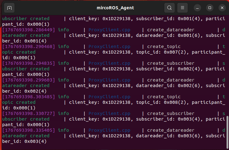
image-20260106192537922

[!NOTE]

Note: To experience this course, you need to first build at least one grid map according to the LiDAR chapter.


2.1 Configuring the Map Mapping File

  • Command to start navigation on the vehicle's infotainment system

For Raspberry Pi 5 users, if the ROS container is not running, you need to start it first.

xxxxxxxxxx
bringup_m3

Open a terminal inside the container.

xxxxxxxxxx
exec_m3

(ORIN mainboard)

xxxxxxxxxx
ros2 launch m3_bringup nav2.launch.py

(RDK & PI5 mainboard) Step-by-step execution, visualized on the accompanying virtual machine Rosmaster-M3-Ubuntu22.04, start it.

​x
#Virtual machine side
rviz2 -d /home/yahboom/yahboomM3_ws/user_ws/src/m3_bringup/rviz/nav2.rviz
​
#Host side
ros2 launch m3_bringup nav2.launch.py gui:=False

[!TIP]

  • The AMCL positioning algorithm is used for navigation by default here, which is suitable for most applicable scenarios. If higher positioning accuracy is required, please refer to the product tutorial [02.Lidar Course]—[13.slam_toolbox localization and navigation] section to build a pose map and use the slam_toolbox pure positioning mode for navigation.

Next, the rviz2 visualization interface will open. Click on 2D Pose Estimate in the top toolbar to enter selection mode. Roughly mark the robot's location and orientation on the map.

The robot's model will be displayed on the map, as shown below:
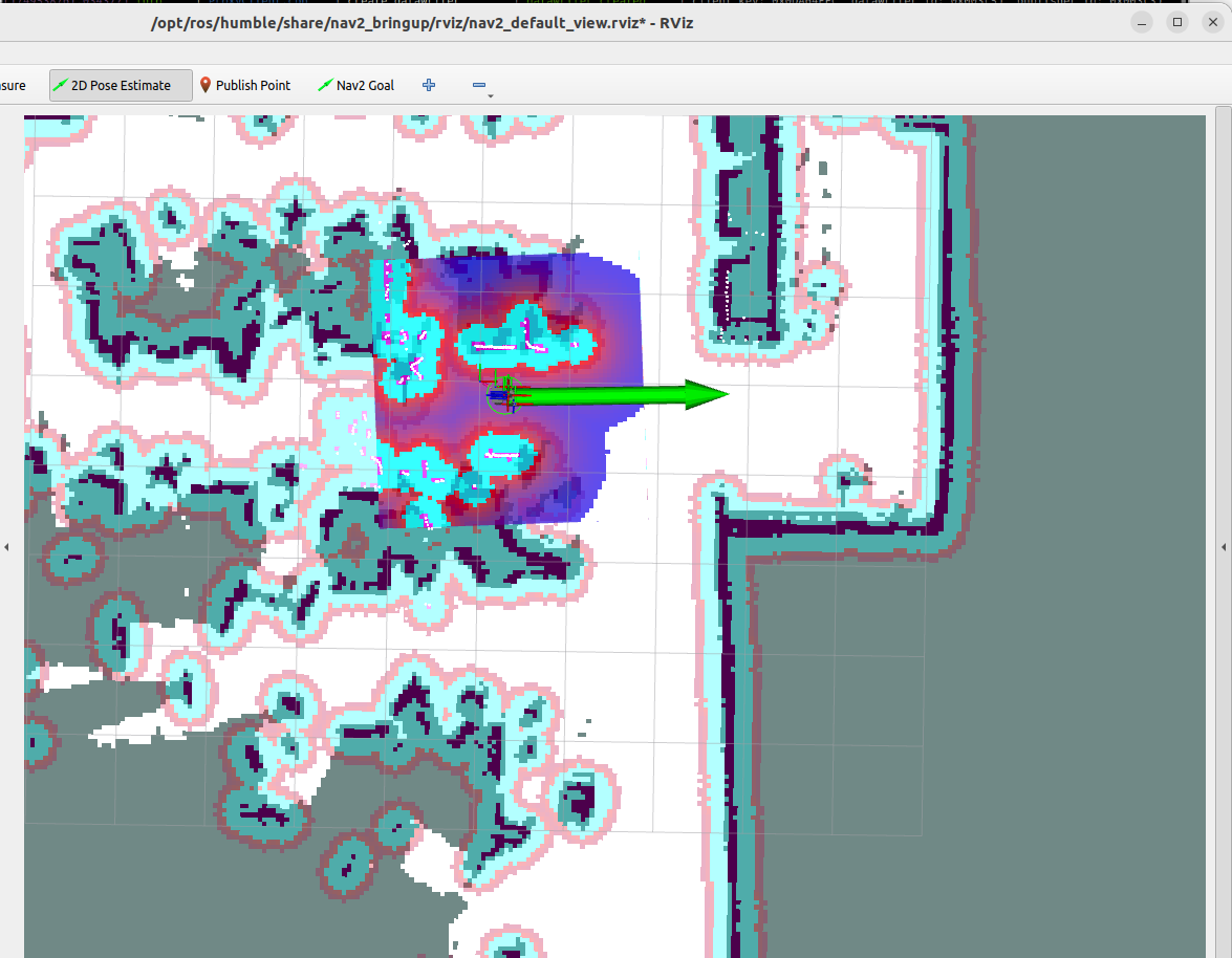
image-20251222180506765

We can name any precise point on the map. Here, we use "Master Bedroom" and "Kitchen" as examples.
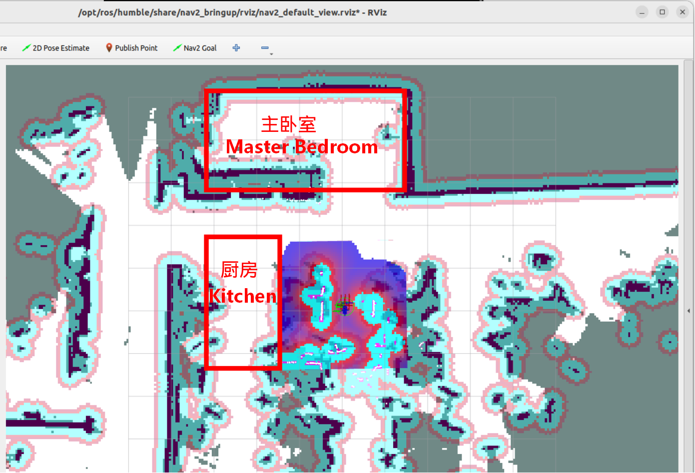
image-20251222181040840

As shown in the image below, we first click on Nav2 The Goal tool guides the vehicle's navigation system to the target location we need to mark.
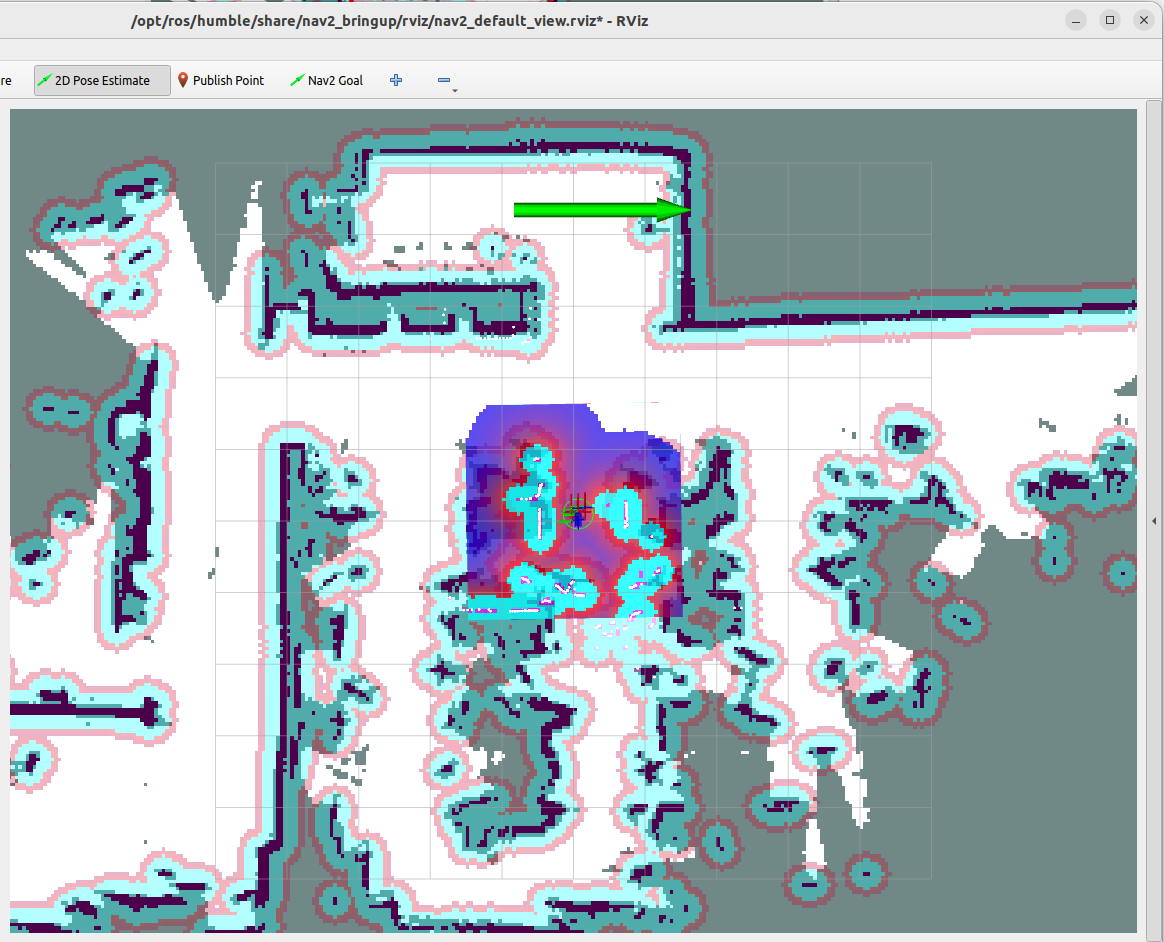
image-20251222181424027

Wait for the vehicle's navigation system to reach the target location to be marked.
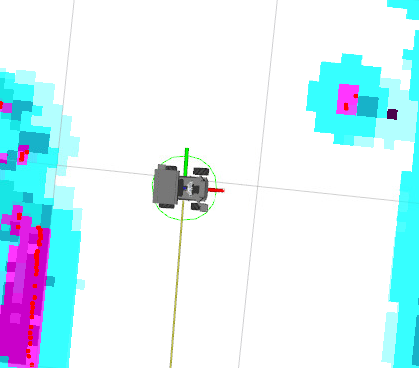
image-20250805145419328

  • Run the following command in the terminal to obtain the robot's pose information in the map coordinate system:
xxxxxxxxxx
ros2 run tf2_ros tf2_echo map base_footprint
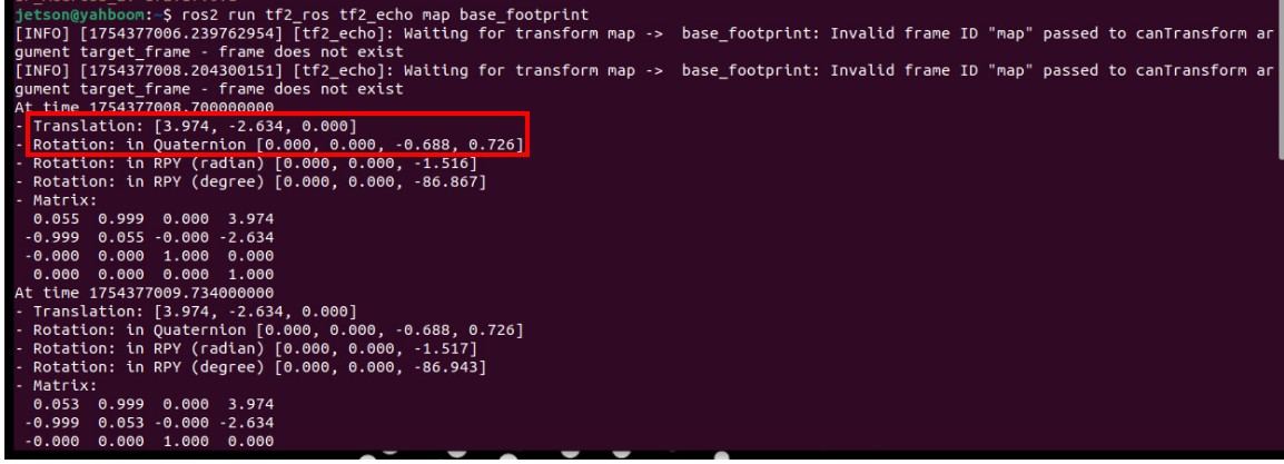
image-20251222181656494

Open the map_mapping.yaml map mapping file (you can choose any method to open it, such as VNC, vscode, or command line):

  • Here's an example of opening the map configuration file via command line:
xxxxxxxxxx
nano ~/yahboomM3_ws/user_ws/src/m3_bringup/config/multi_brains/map_mapping.yaml
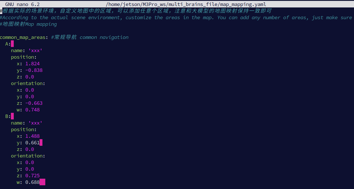
image-20251222183638580

  • Modify the symbolic pose under the common_map_areas field, where name is the location name, and fill in the previously obtained poses into the position and orientation fields.
xxxxxxxxxx
#根据实际的场景环境,自定义地图中的区域,可以添加任意个区域,注意和大模型的地图映射保持一致即可
#According to the actual scene environment, customize the areas in the map. You can add any number of areas, just make sure they are consistent with the map mapping of the large model
#地图映射Map mapping
​
common_map_areas: #常规导航 common navigation
  A: 
  name: 'Master bedroom'
  position:
    x: 3.974
    y: -2.634
  orientation:
    x: 0.0
    y: 0.0
    z: -0.688
    w: 0.726
  B: 
    name: 'xxx'
    position:
      x: 1.488
      y: 0.661 
      z: 0.0
    orientation:
      x: 0.0
      y: 0.0
      z: 0.725
      w: 0.688  


  • After configuring all the points that need to be marked, save the file (Ctrl+X) for immediate effect.

2.2 Configuring Map Mapping Variables in Dify

  • After configuring the map mapping file above, we also need to ensure that the AI model knows in advance the relationships between locations and symbols in these maps.
  • Start the Dify service (if it is already running, there is no need to start it again):
xxxxxxxxxx
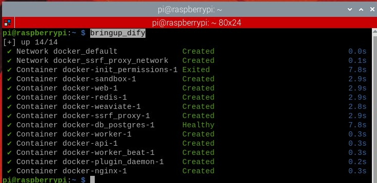
bringup_dify

image-20251218112736396


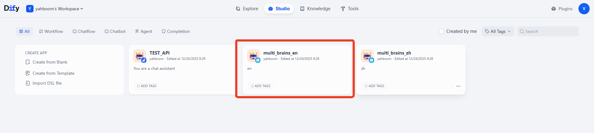
  • Enter the vehicle's IP address directly into your browser's address bar to access the Dify management page, then click to select the corresponding AI application.

[!NOTE]

  • Domestic users: multi_brains_zh
  • International users: multi_brains_en

image-20251223100441978


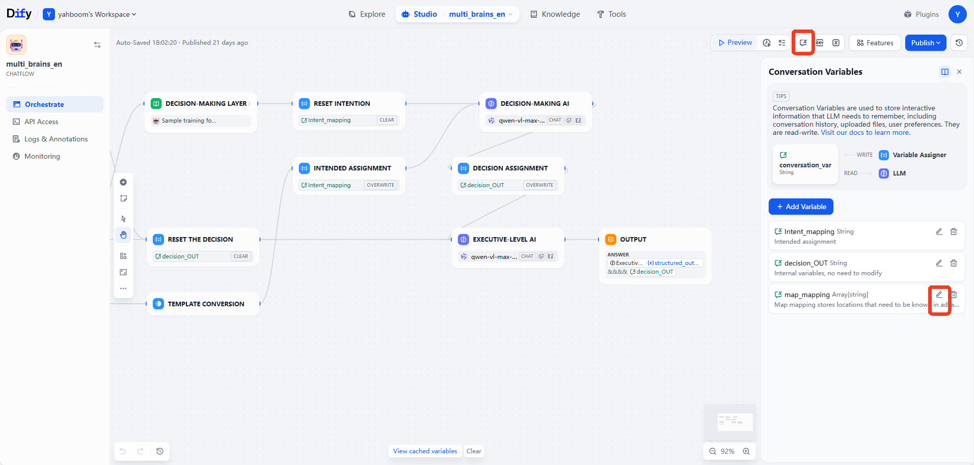
  • Click to select Session Variables in the upper right corner, and then click the edit button for the map_mapping variable.

image-20251223100744100


  • In the pop-up Edit Session Variables window, edit the mapping relationships according to the settings in the previous map mapping file, and then click Save.
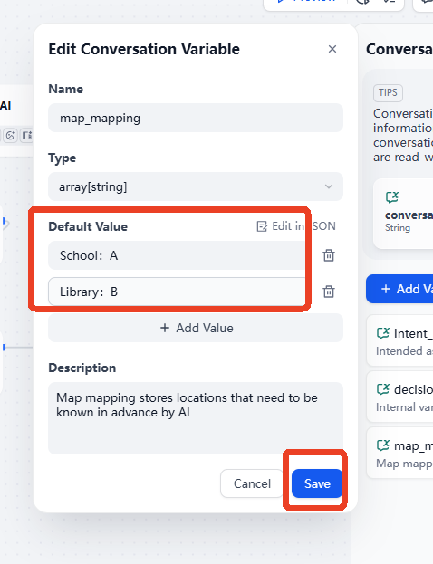
image-20251223101135772


Finally, remember to click "Publish" -> "Publish Update" to save your changes.
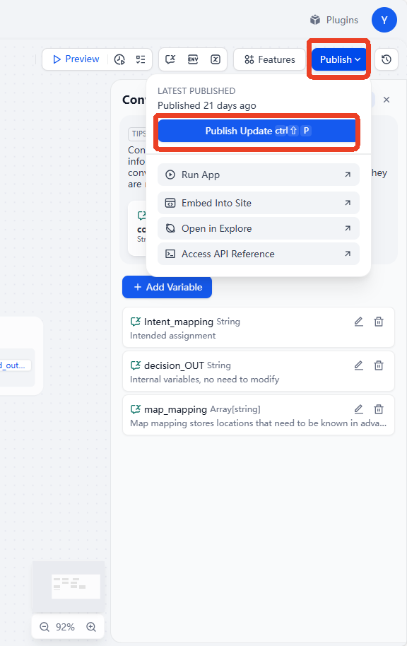
image-20251223101356712

3. Running Examples

3.1 Starting the Program

  • Open the terminal on the vehicle's infotainment system and enter the command to start the AI intelligent agent system, or you can use the shortcut: multi_brains to start the AI large model function:
xxxxxxxxxx
ros2 launch m3_bringup llm_agent_control.launch.py
  • Command to start navigation on the vehicle's infotainment system

(ORIN & PI5 mainboard)

xxxxxxxxxx
ros2 launch m3_bringup nav2.launch.py

(RDK mainboard) Run in steps, and visualize the process by starting the accompanying virtual machine Rosmaster-M3-Ubuntu22.04:

xxxxxxxxxx
#Virtual Machine
rviz2 -d /home/yahboom/yahboomM3_ws/user_ws/src/m3_bringup/rviz/nav2.rviz
#Host side
ros2 launch m3_bringup nav2.launch.py gui:=False
  • Afterwards, follow the navigation activation process to initialize positioning. This will open the rviz2 visualization interface. Click on 2D Pose Estimate in the top toolbar to enter selection mode. Roughly mark the robot's location and orientation on the map. After initial positioning, the preparation is complete.
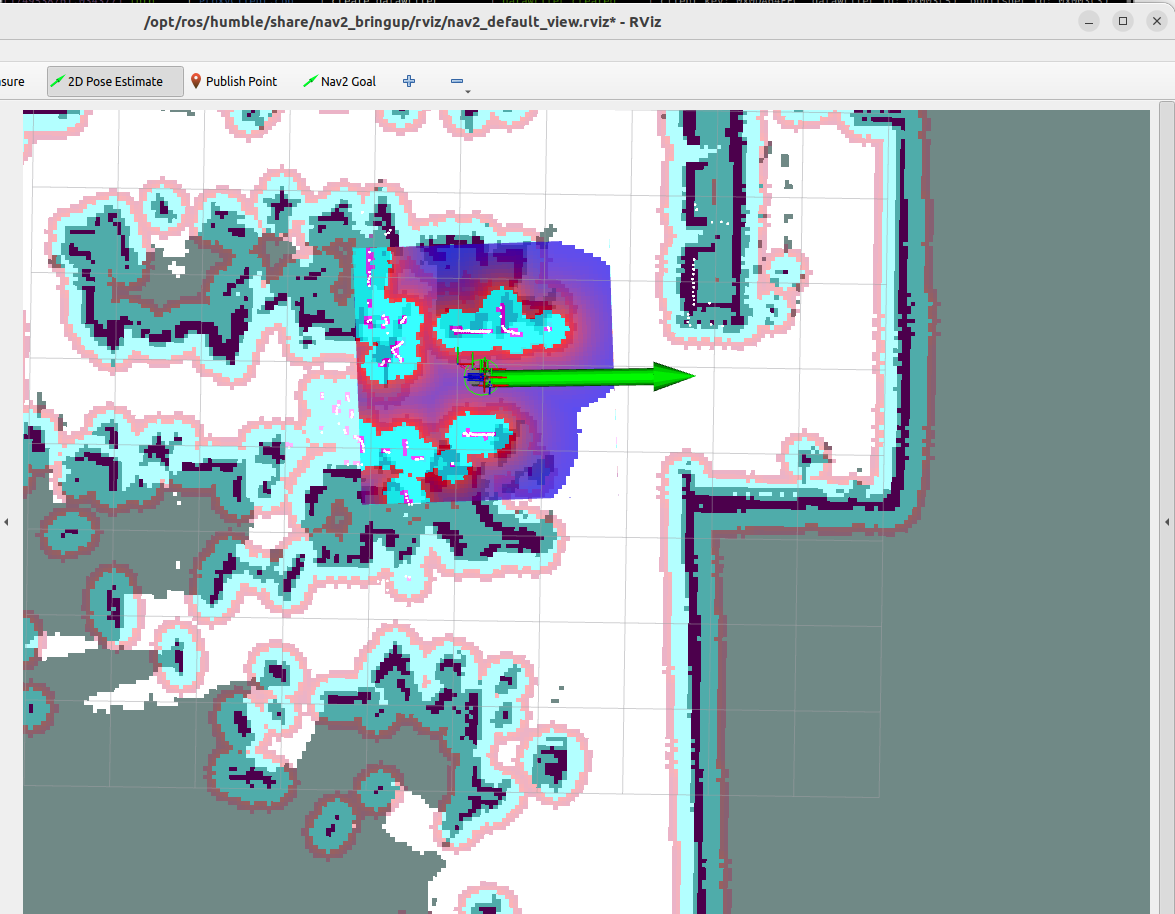
image-20251223095555351

3.2 Test Cases

These test cases are for reference only. Provide instructions according to your own needs.

  • Please remember your current location, then navigate to the kitchen and the master bedroom in that order, remembering the items you see in each room. Finally, return to your starting position and tell me what you saw in those two places.
  • Wake up the robot and issue commands. The execution layer model will execute sub-tasks according to the task steps planned by the decision layer model. 1. Navigate to the "master bedroom" and observe the items in the environment. Place a pen in the simulated "master bedroom" and a pack of toilet paper in the simulated "kitchen":
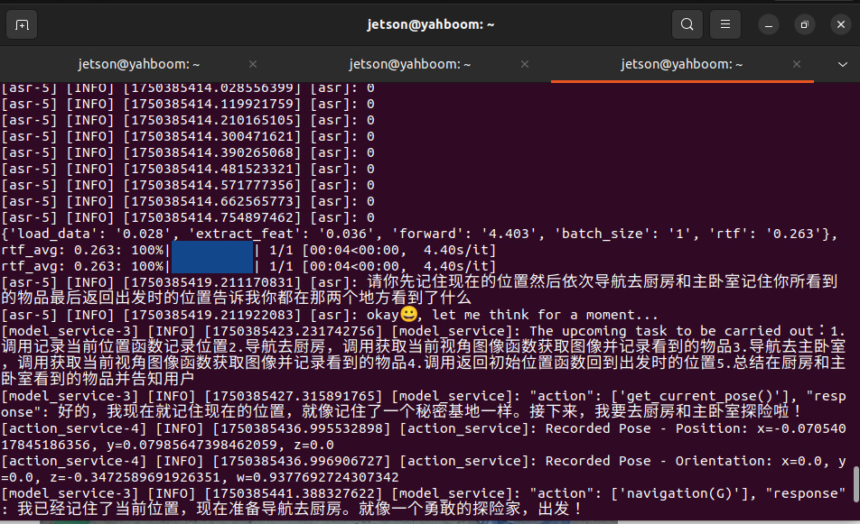
image-20251223095604868

  • The robot executes the following steps according to the output flow of the decision layer:
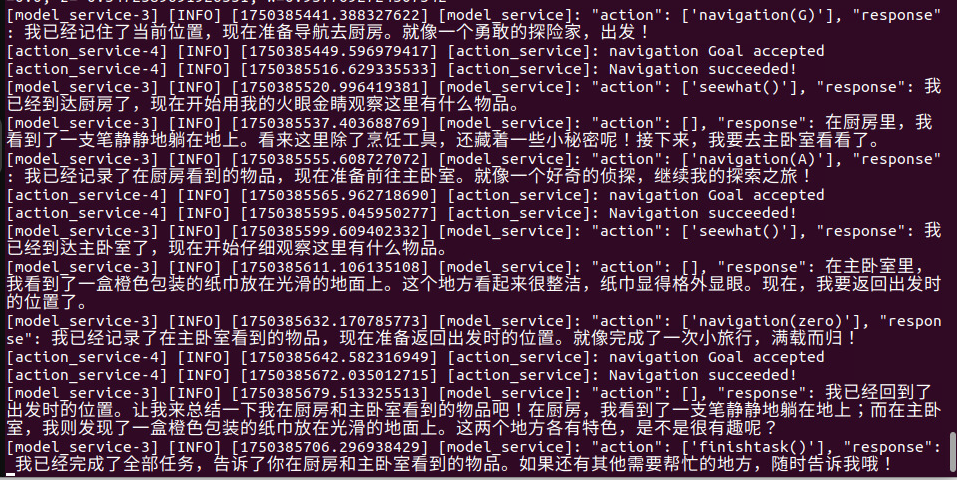
image-20251223095612492

4. Source Code Analysis

  • Robot motion source code path:
xxxxxxxxxx
~/yahboomM3_ws/code_ws/src/multi_brains/multi_brains/action_service.py

action_service.py program:

Case 1 uses the seewhat, navigation, load_target_points, and get_current_pose methods from the CustomActionServer class. Seewhat has already been explained in the Multimodal Visual Understanding + Robotic Arm Grasping chapter. This lesson explains the newly introduced navigation, load_target_points, and get_current_pose functions.

init_ros_comunication initialization function:

  • Creates a nav2 navigation client to request the ros2 navigation action server for subsequent navigation target point requests; creates a TF listener to monitor coordinate transformations between the map and basefootprint.
xxxxxxxxxx
# Create a navigation client and request the navigation action server.
self.navclient=ActionClient(self, NavigateToPose, 'navigate_to_pose')
# Create a TensorFlow listener to monitor coordinate transformations
self.tf_buffer = Buffer()
self.tf_listener = TransformListener(self.tf_buffer, self)


The load_target_points function:

  • Loads the target point coordinates from the map mapping file map_mapping.yaml and creates a navigation dictionary to store the characters and their corresponding map coordinates, where each point coordinate is a PoseStamped type data.
xxxxxxxxxx
    def load_target_points(self):
        """
        加载地图映射文件 /Load map mapping file
        """
        self.navpose_dict = {}
        self.road_net_dict = {}
        with open(self.map_mapping_file, "r") as file:
            full_target_points = yaml.safe_load(file)
            common_target_points = full_target_points.get("common_map_areas", {})
            road_net_target_points = full_target_points.get("road_net_map_areas", {})
​
        for name, data in common_target_points.items():#加载常规导航点 / Load common navigation points
            pose = PoseStamped()
            pose.header.frame_id = "map"
            pose.pose.position.x = data["position"]["x"]
            pose.pose.position.y = data["position"]["y"]
            pose.pose.position.z = data["position"]["z"]
            pose.pose.orientation.x = data["orientation"]["x"]
            pose.pose.orientation.y = data["orientation"]["y"]
            pose.pose.orientation.z = data["orientation"]["z"]
            pose.pose.orientation.w = data["orientation"]["w"]
            self.navpose_dict[name] = pose
​


The __normal_navigation function:

  • Receives a character parameter (corresponding to the character in the map mapping above), parses the coordinates of the corresponding character from the dictionary, and uses the self.navclient navigation client object to request the ROS2 navigation action server. When the navigation action server returns a value of 4, it indicates successful navigation; other values indicate failure (possibly due to obstacles, planning failure, etc.). After navigation is complete, the result of the action execution is fed back to the large model.
xxxxxxxxxx
    def __normal_navigation(self, point_name)->None:
        '''常规导航功能 / Normal navigation function '''
        self.navigation_finish_flag = False
        self.goal_handle = None
        self.result = None
        self.res = None
        point_name = point_name.strip("'\"")
        if point_name not in self.navpose_dict:
            self.get_logger().error(f"Target point '{point_name}' does not exist in the navigation dictionary." )
            return None
​
        if self.first_record:
            # 出发前记录当前在全局地图中的坐标(只有在每个任务周期的第一次执行时才会记录)/ before starting a new task, record the current pose in the global map
            transform = self.tf_buffer.lookup_transform(
                "map", "base_footprint", rclpy.time.Time()
            )
            pose = PoseStamped()
            pose.header.frame_id = "map"
            pose.pose.position.x = transform.transform.translation.x
            pose.pose.position.y = transform.transform.translation.y
            pose.pose.position.z = 0.0
            pose.pose.orientation = transform.transform.rotation
            self.navpose_dict["zero"] = pose
            self.road_net_dict["zero"] = pose
            self.first_record = False
​
        # 获取目标点坐标 /get_target_pose
        target_pose = self.navpose_dict.get(point_name)
        goal_msg = NavigateToPose.Goal()
        goal_msg.pose = target_pose
        send_goal_future = self.navclient.send_goal_async(goal_msg)
​
        def goal_response_callback(future):
            self.goal_handle = future.result()
            if not self.goal_handle or not self.goal_handle.accepted:
                self.get_logger().error("Goal was rejected!")
                return None
​
            get_result_future = self.goal_handle.get_result_async()
​
            def result_callback(future_result):
                self.result = future_result.result()
                self.navigation_finish_flag = True
                if self.result.status == 4:
                    self.get_logger().info("Navigation finished!")
                    self.res= True
                else:
                    self.get_logger().info(f"Navigation failed with status: {self.result.status}")
                    self.res= False
​
            get_result_future.add_done_callback(result_callback)
        send_goal_future.add_done_callback(goal_response_callback)
​
        while not self.navigation_finish_flag:
            if self.interrupt_event.is_set() :
                self.navclient._cancel_goal(self.goal_handle)
                return None
            time.sleep(0.1)
        self.stop()
        return self.res

The get_current_pose function retrieves the robot's current map coordinates in the global coordinate system and adds these coordinates to a dictionary for later retrieval.

xxxxxxxxxx
    def get_current_pose(self):
        """
        获取当前在全局地图坐标系下的位置 /Get the current position in the global map coordinate system
        """
        transform = self.tf_buffer.lookup_transform("map", "base_footprint", rclpy.time.Time())
        pose = PoseStamped()
        pose.header.frame_id = "map"
        pose.pose.position.x = transform.transform.translation.x
        pose.pose.position.y = transform.transform.translation.y
        pose.pose.position.z = 0.0
        pose.pose.orientation = transform.transform.rotation
        self.navpose_dict["zero"] = pose
        position = pose.pose.position
        orientation = pose.pose.orientation
        self.get_logger().info(f"Recorded Pose: Position: x={position.x}, y={position.y},z={position.z},Orientation: x={orientation.x}, y={orientation.y}, z={orientation.z}, w={orientation.w}")
        return True


Multimodal visual understanding
Intention estimation

COMPANY

  • About us
  • Team Style
  • Blog

LEARNING & EXPLORATION

  • Tutorials
  • Edge AI hardware
  • Educational robots
  • Embedded intelligent hardware

WHERE TO BUY

  • Yahboom Online Store
  • Amazon
  • Alibaba
  • AliExpress
  • Mercado

TECHNOLOGY SUPPORT

  • Email: support@yahboom.com

BE A DISTRIBUTOR

  • Email: sales@yahboom.com
QR Code

Copyright © 2017-2026 Yahboom. All Rights Reserved.

EN/中文