Welcome to ROSMASTER M1 PRO repository
15.Aruco Visual Relocalization Navigation
Aruco Marker Visual Relocalization Navigation
Aruco Marker Visual Relocalization Navigation1. Course ContentLearning Objectives2. Preparation3. Recording the ArUco Tag Map Coordinates3.1 Preparing the ArUco Tags3.2 Deploying the ArUco Tags3.3 Starting the Tag Recording Node4. Starting the Visual Relocalization Navigation Mode4.1 Verifying the Relocalization Feature4.2 Controlling Tag Detection via Service5. Source Code Analysis5.1 Tag Recording Node Launch File5.2 Relocalization Mode Navigation Launch File5.3 aritag_relocation.yaml File Structure5.4 Visual Relocalization Working Principle5.5 Tag Configuration Parameters5.6 Inter-Node Communication Graph
1. Course Content
Use ArUco tags combined with the pose map's constraint solving function to implement the visual relocalization navigation feature.
By deploying ArUco tags as spatial anchors, when the robot's localization is lost or the accumulated error is too large, visual detection is used to automatically trigger relocalization, correct the robot's global pose in the map, and improve the robustness and reliability of the navigation system.
Note
The visual relocalization scheme here is used in subsequent OpenClaw courses and sandbox map courses to enhance global localization stability
Learning Objectives
Master the methods for preparing, deploying, and recording the positions of ArUco tags
Understand the working principles and applicable scenarios of visual relocalization
Learn to use the navigation mode that combines pose constraints with visual relocalization
2. Preparation
Referring to the prerequisite course 【Slam-Toolbox Mapping】, complete a grid map and a pose map in posegraph format; mapping and saving the map can be done either through the UI panel or CLI commands
Important
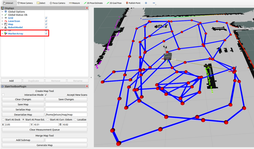
Pose points must be checked: when mapping with slam_toolbox, click the MarkerArray option in the Display panel in Rviz to view the pose map's pose points. Make sure there are enough pose points within the map area for localization during subsequent navigation.
3. Recording the ArUco Tag Map Coordinates
3.1 Preparing the ArUco Tags
They can be obtained in the following ways:
The tags from the sandbox map package
Download and print the tags yourself from the attached materials
Determine the size of the tags
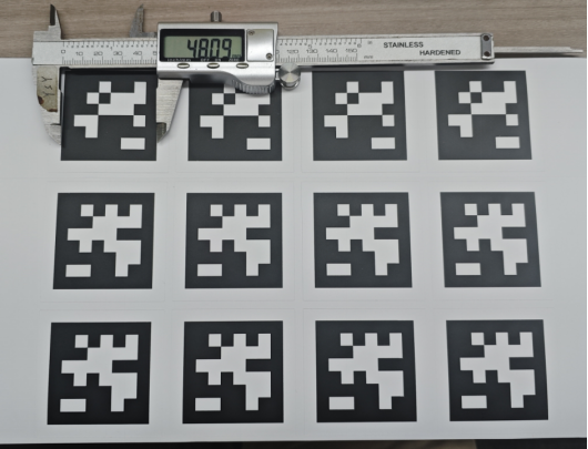
Measure the tags' actual side length with a measuring tool; the side length of the tags included in the sandbox map package is 0.048m
If the tags are printed by yourself, their actual size needs to be measured manually due to printer size scaling
Modify the ArUco detection configuration file
~/yahboomcar_ros2_ws/yahboomcar_ws/src/yahboomcar_bringup/param/common.yaml
Modify size to the actual size. If you are using the tags included with the sandbox map, the factory default size is 0.048 and does not need to be modified
xxxxxxxxxx...apriltag# node name ros__parameters image_transportraw # image format: "raw" or "compressed" family36h11 # tag family name: 16h5, 25h9, 36h11 size0.048 # default tag edge size in meter...
3.2 Deploying the ArUco Tags
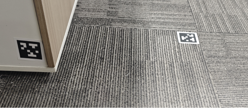
Place the ArUco tags at the required positions in the map. They can be placed anywhere the camera can observe, such as on the floor or walls.
Important
Placement tips
It is recommended to place them near frequently navigated start or end points within the camera's field of view, triggering relocalization before the car departs or after it stops upon reaching the goal point
It is not recommended to place them along the driving path, because when the car is moving, the robotic arm produces mechanical swaying, causing the camera image to shake frequently and making the computed car position inaccurate
3.3 Starting the Tag Recording Node
xxxxxxxxxxros2 launch yahboomcar_bringup record_tag.launch.py
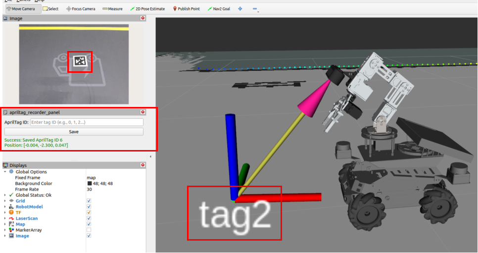
Step 1: Move the car (by carrying it directly or controlling it to move) near the tag to be recorded, make the tag appear in the camera's field of view, and observe that the tag number in RVIZ looks like
TagxStep 2: In the ArUco ID field of the aritag_recorder_panel panel, enter the ID of the tag to be recorded, then click Save to complete the recording (check whether the car's localization is accurate before recording)
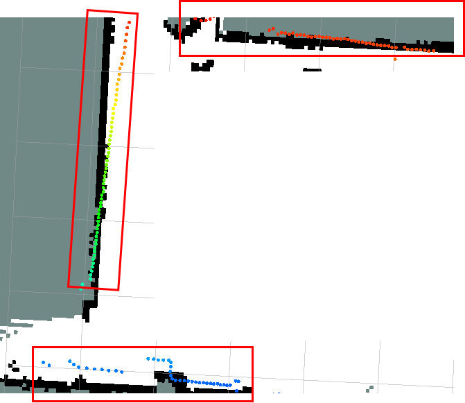
Before recording the tag position, if you find that the laser contour deviates significantly from the environmental edge features, as shown below, it proves that there is an error in the localization. In this case, you need to first use the 2D Pose Estimate tool for manual relocalization before recording the position
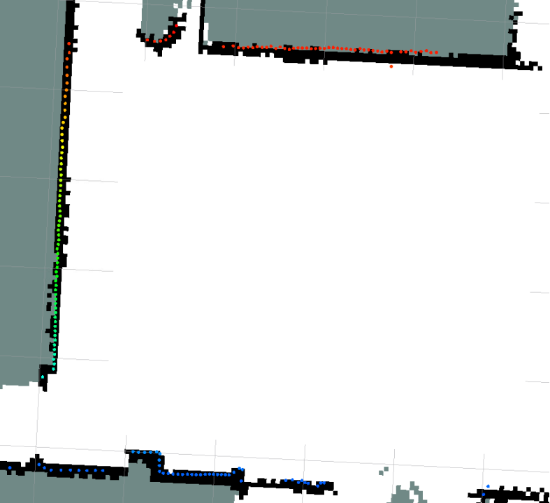
The figure below proves that the localization is accurate, with a high degree of matching between the laser contour and the environmental edge features
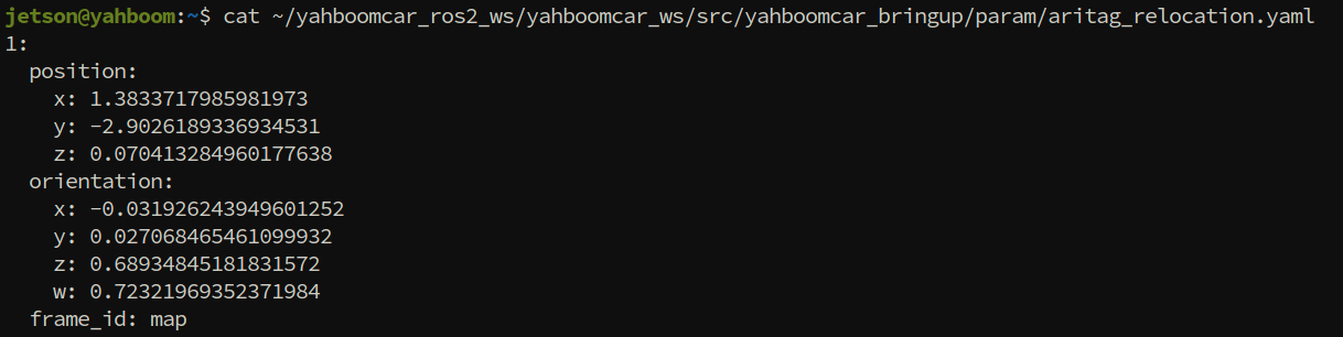
Repeat the above steps to complete the position recording of all tags. Record file path:
xxxxxxxxxx~/yahboomcar_ros2_ws/yahboomcar_ws/src/yahboomcar_bringup/param/aritag_relocation.yaml
4. Starting the Visual Relocalization Navigation Mode
xxxxxxxxxxros2 launch yahboomcar_bringup aruco_relocation_nav.launch.py
The green circles Txx displayed on the map in the image are the positions of all the tags recorded in the previous steps. They may not be displayed immediately right after startup; the tag data is periodically published on the /apriltag_map_markers topic and displayed by RVIZ after subscription
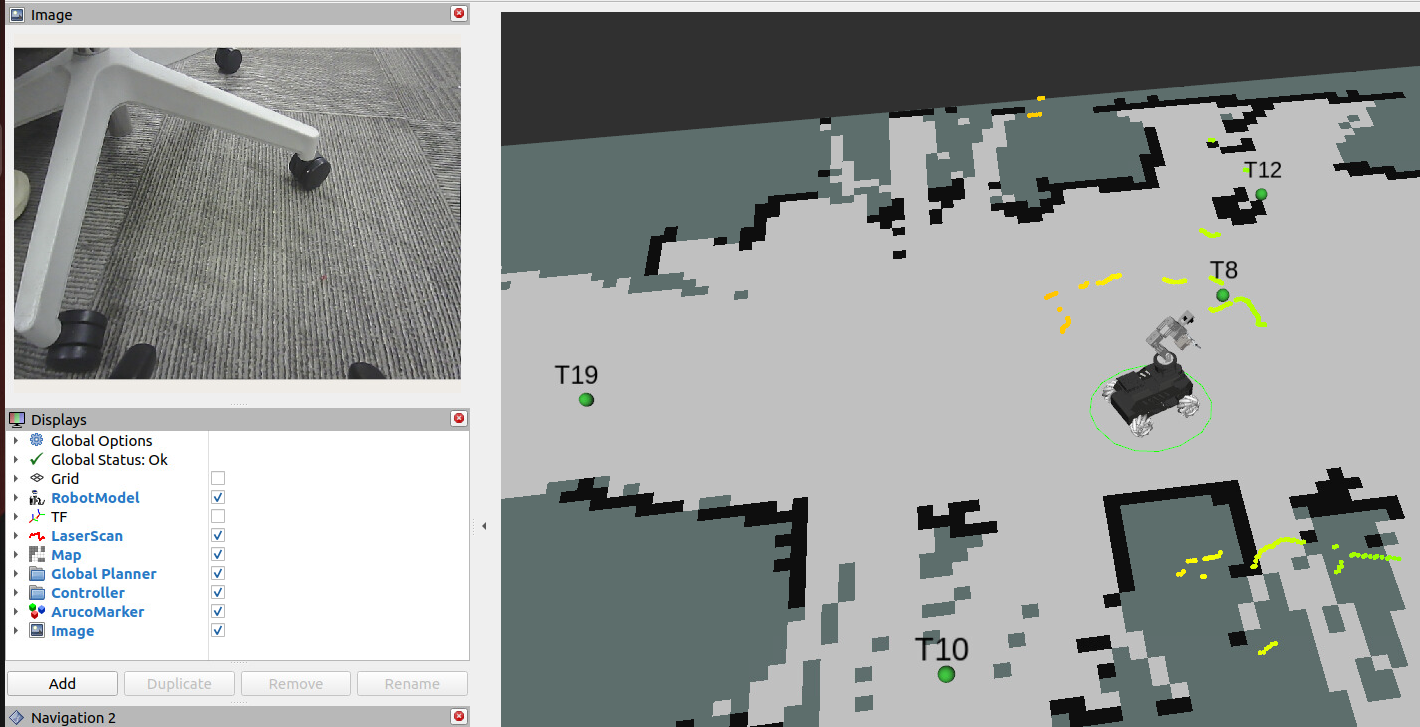
4.1 Verifying the Relocalization Feature
You can manually move the robot's position (to simulate a situation where the odometry has severe error and the global localization is chaotic, as shown in the figure above)
When a tag in the map is seen in the camera's field of view, relocalization is automatically triggered to correct the robot's global localization in the map
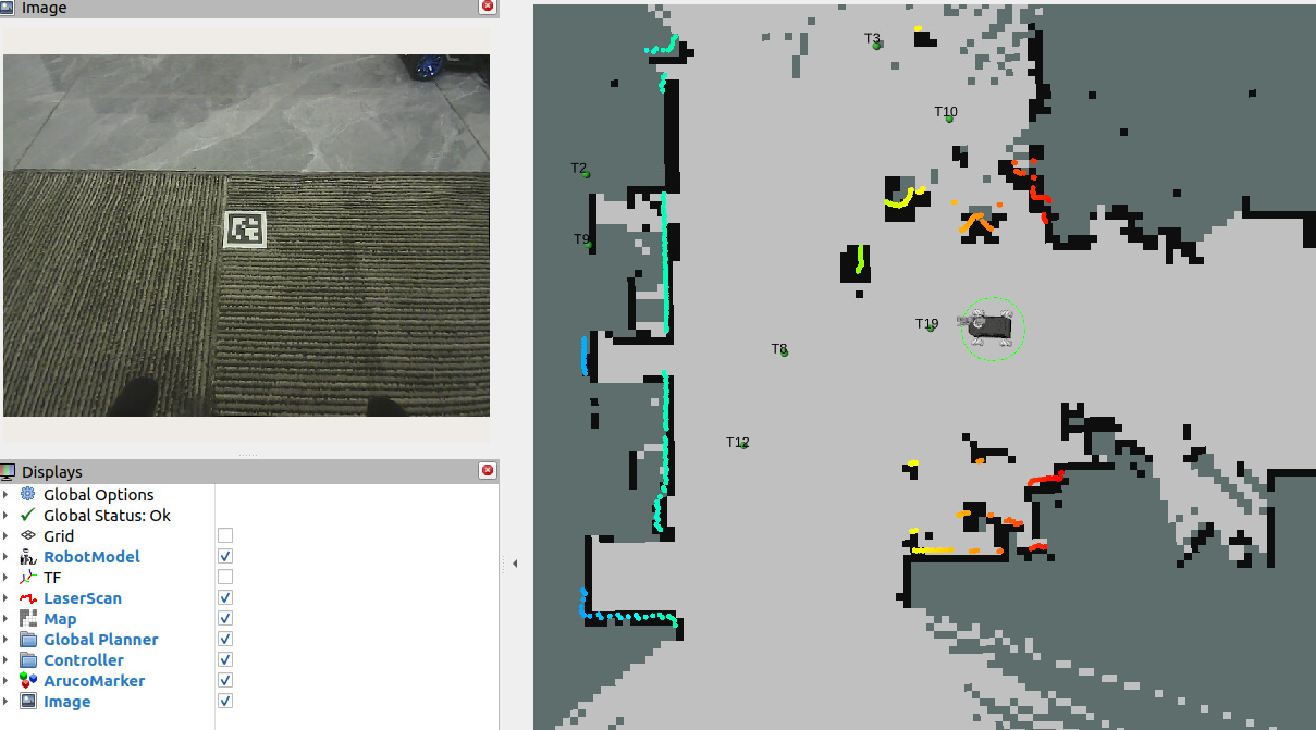
The terminal will indicate the detected Aruco marker ID through logs

4.2 Controlling Tag Detection via Service
Because the aritag tag detection node occupies the CPU at a high frequency, you can turn off the detection state when detection is not needed. The node provides a control_detection service to control whether tag detection is performed
Query status
xxxxxxxxxxros2 service call /control_detection apriltag_localization/srv/ControlDetection "{command: 0}"

Enable detection
xxxxxxxxxxros2 service call /control_detection apriltag_localization/srv/ControlDetection "{command: 1}"

Disable detection (reduces CPU usage)
xxxxxxxxxxros2 service call /control_detection apriltag_localization/srv/ControlDetection "{command: 2}"

5. Source Code Analysis
5.1 Tag Recording Node Launch File
xxxxxxxxxx~/yahboomcar_ros2_ws/yahboomcar_ws/src/yahboomcar_bringup/launch/record_tag.launch.py
apriltag_detect: starts theapriltag_nodetag detection node, loads thecommon.yamlconfiguration and enables detection, and remaps the camera image and camera_info topicsapriltag_recorder_node: starts theapriltag_recorderrecording node, which listens to the detected tag poses and saves them to the YAML file specified byoutput_file_path, with the coordinate frame beingtarget_frame(defaultmap)navigation_launch: includesnav2.launch.py, uses the slam_toolbox localization mode, does not start the chassis (start_carbase: false), and loads the dedicatedrecord_tagRviz configurationcall_detection_service: calls the/control_detectionservice after a 5-second delay to enable tag detection (command: 1), waiting for the system to fully start before enabling to avoid resource conflictscar_base_launch: includescar_base.launch.py, enabling the IMU, LiDAR, and camera, and using the EKF odometry as the TF source
x apriltag_detect = Node( package='apriltag_localization', executable='apriltag_node', name='apriltag', parameters=[os.path.join(get_package_share_directory('yahboomcar_bringup'),'param','common.yaml'), {"detection_enabled": True}], remappings=[('/image_rect', GetCameraRgbTopic()), ('/image_rect/camera_info', GetCameraInfo())], output='screen' ) # AprilTag recorder node apriltag_recorder_node = Node( package='apriltag_localization', executable='apriltag_recorder', name='apriltag_recorder', output='screen', parameters=[{ 'output_file_path': LaunchConfiguration('output_file_path'), 'target_frame': LaunchConfiguration('target_frame'), }] ) #slam_toolbox_navigation navigation_launch = IncludeLaunchDescription( PythonLaunchDescriptionSource(os.path.join(get_package_share_directory('yahboomcar_bringup'),'launch','nav2.launch.py')), launch_arguments={'log_level': 'warn', 'start_carbase': 'false', 'localization_mode':'slam_toolbox', 'rviz_config': 'record_tag' }.items())
# Enable aritag detection call_detection_service = TimerAction( period=5.0, actions=[ ExecuteProcess( cmd=['ros2', 'service', 'call', '/control_detection', 'apriltag_localization/srv/ControlDetection', '{command: 1}'], output='screen' ) ] ) car_base_launch = IncludeLaunchDescription( PythonLaunchDescriptionSource(os.path.join(get_package_share_directory('yahboomcar_bringup'),'launch','car_base.launch.py')), launch_arguments={ 'use_imu': 'True', 'use_lidar': 'True', 'use_camera': 'True', 'odom_tf_source': 'ekf' }.items())
5.2 Relocalization Mode Navigation Launch File
xxxxxxxxxx~/yahboomcar_ros2_ws/yahboomcar_ws/src/yahboomcar_bringup/launch/aruco_relocation_nav.launch.pydeclared_arguments: declares thervizlaunch parameter, default valueTrue, controlling whether to automatically start Rviz2apriltag_relocalization: includesapriltag_relocalization.launch.py, enabling tag detection (detection_enabled: true), which detects tags and triggers relocalizationcar_base_launch: includescar_base.launch.py, enabling the IMU, LiDAR, and camera, and using the EKF odometry as the TF sourcenav2: includesnav2.launch.py, uses the slam_toolbox localization mode, does not start the chassis (start_carbase: False), and loads thearuco_relocation_nav.rvizconfigurationLaunchDescription: aggregates and returns the three modules of chassis launch, navigation, and tag relocalization
xxxxxxxxxxdef generate_launch_description(): bringup_dir = get_package_share_directory('yahboomcar_bringup') declared_arguments = [] declared_arguments.append( DeclareLaunchArgument( "rviz", default_value='True', description="if rviz is used, set to True. If False, rviz will not be launched.", ) ) apriltag_relocalization=IncludeLaunchDescription( PythonLaunchDescriptionSource(os.path.join(bringup_dir,'launch','apriltag_relocalization.launch.py')), launch_arguments={'detection_enabled': 'true', 'log_level': 'info'}.items()) # Car base with camera and lidar car_base_launch = IncludeLaunchDescription( PythonLaunchDescriptionSource(os.path.join(bringup_dir,'launch','car_base.launch.py')), launch_arguments={ 'use_imu': 'True', 'use_lidar': 'True', 'use_camera': 'True', 'odom_tf_source': 'ekf' }.items()) nav2=IncludeLaunchDescription( PythonLaunchDescriptionSource(os.path.join(bringup_dir,'launch','nav2.launch.py')), launch_arguments={'localization_mode':'slam_toolbox', 'start_carbase': 'False', 'log_level':'warn', 'rviz': LaunchConfiguration('rviz'), 'rviz_config': 'aruco_relocation_nav.rviz' }.items()) return LaunchDescription([ *declared_arguments, car_base_launch, nav2, apriltag_relocalization, ])
5.3 aritag_relocation.yaml File Structure
The structure of the aritag_relocation.yaml file generated after recording is complete is as follows:
xxxxxxxxxxtagsid0 # ArUco tag ID position# Position coordinates (relative to the map coordinate frame) x1.234 # X coordinate (meters) y0.567 # Y coordinate (meters) z0.0 # Z coordinate (meters; usually 0, representing ground level) orientation# Orientation (quaternion) x0.0 y0.0 z0.123 w0.987id1 position x2.345 y1.234 z0.0 orientation x0.0 y0.0 z0.456 w0.890Field description:
| Field | Type | Description |
|---|---|---|
id | int | The unique identifier ID of the ArUco tag |
position.x | float | The tag's X coordinate in the map coordinate frame (meters) |
position.y | float | The tag's Y coordinate in the map coordinate frame (meters) |
position.z | float | The tag's Z coordinate in the map coordinate frame (meters) |
orientation.x/y/z/w | float | The tag's orientation quaternion, representing the tag's facing direction |
5.4 Visual Relocalization Working Principle
Detect the ArUco tags: the camera continuously detects ArUco tags within its field of view
Match global coordinates: if a tag is detected, read its global coordinates from
aritag_relocation.yamlCalculate the deviation: compare the position estimated by the current odometry with the true position provided by the ArUco tag
Correct the pose: use the ArUco tag's position to correct the robot's global pose
Relocalization advantages:
✅ Eliminates accumulated error: the odometry accumulates error over time, while the ArUco tag provides an absolute position reference
✅ Solves degraded scenarios: in areas with similar features such as long corridors, laser SLAM may produce chaotic localization, while the ArUco tag provides a reliable anchor
Notes: ⚠️ Before recording the tag position, you must ensure that the laser localization is accurate (the laser contour matches the environmental edges) ⚠️ If a tag's position changes, its global coordinates need to be recorded again
5.5 Tag Configuration Parameters
Configuration parameter file path for the tag node
xxxxxxxxxx~/yahboomcar_ros2_ws/yahboomcar_ws/src/yahboomcar_bringup/param/common.yaml
Parameter description:
| Parameter | Description | Default Value |
|---|---|---|
image_transport | Image transport format; raw is raw image, compressed is compressed image | raw |
family | ArUco tag family type; different families use different encoding methods | 36h11 |
size | The tag's physical side length (unit: meters); must match the actual size | 0.048 |
profile | Whether to output performance profiling information | false |
max_hamming | Maximum allowed Hamming distance (number of correctable bits); 0 means no error correction | 0 |
detector.threads | Number of detection threads | 1 |
detector.decimate | Pyramid downsampling factor; a larger value makes detection faster but reduces accuracy | 2.0 |
detector.blur | Gaussian blur sigma value, used for quad detection | 0.0 |
detector.refine | Whether to enable edge sharpening for precise localization | true |
detector.sharpening | Sharpening strength of the decoded image | 0.25 |
detector.debug | Whether to output debug images to the current working directory | false |
pose_estimation_method | Pose estimation method; pnp means using the PnP algorithm | pnp |
tag.ids | List of tag IDs to detect; only tags appearing in the list are detected | [1-20] |
tag.frames | List of TF coordinate frame names corresponding to the IDs | [tag1-tag20] |
Important parameter tuning suggestions:
size: must be measured accurately and set; errors will cause incorrect pose computationfamily: must match the tag family used, otherwise detection will failtag.ids: only list the tag IDs actually used, to reduce unnecessary TF publishing
xxxxxxxxxx...apriltag# node name ros__parameters image_transportraw # image format: "raw" or "compressed" family36h11 # tag family name: 16h5, 25h9, 36h11 size0.048 # default tag edge size in meter profilefalse # print profiling information to stdout # tuning of detection (defaults) max_hamming0 # maximum allowed hamming distance (corrected bits) detector threads1 # number of threads decimate2.0 # decimate resolution for quad detection blur0.0 # sigma of Gaussian blur for quad detection refinetrue # snap to strong gradients sharpening0.25 # sharpening of decoded images debugfalse # write additional debugging images to current working directory pose_estimation_method"pnp" # method for estimating the tag pose tag ids1 2 3 4567891011121314151617181920 # tag IDs for which to publish transform framestag1 tag2 tag3 tag4 tag5 tag6 tag7 tag8 tag9 tag10 tag11 tag12 tag13 tag14 tag15 tag16 tag17 tag18 tag19 tag20 ...
5.6 Inter-Node Communication Graph
Start it while the relocalization navigation is running:
xxxxxxxxxxros2 run rqt_graph rqt_graph
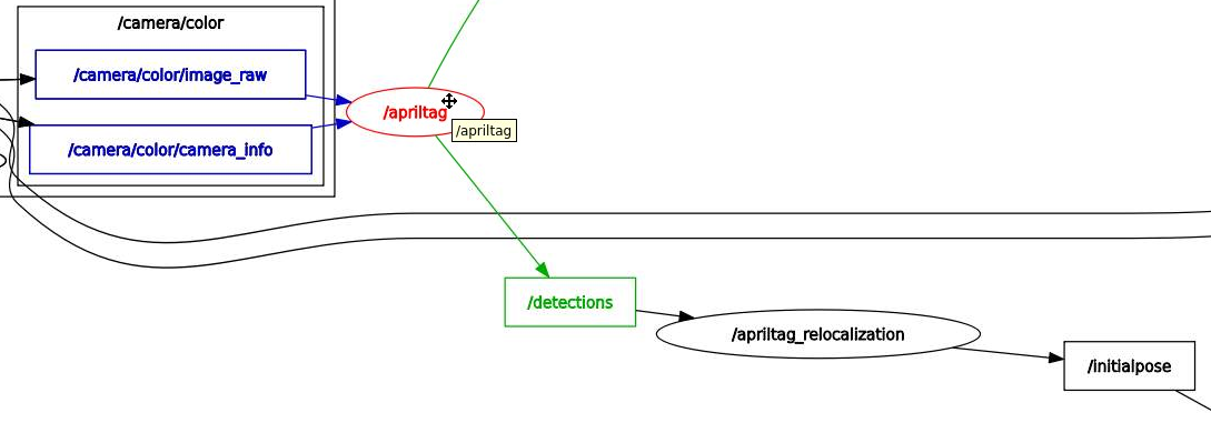
The apriltag node subscribes to the camera topic to detect tags and publishes the /detections topic; the relocalization node apriltag_relocation subscribes to /detections. When a tag is detected, based on the tag's recorded map anchor coordinates, it computes the position of the car's base_link in the map coordinate frame and publishes it to /initialpose, triggering the localization function of the slam_toolbox node to compute the precise coordinate position of the car in the map from the pose constraint graph