yahboom
HomeTutorialsProduct
Solution
Blog
Online Store
About Us
EN/中文
Store
ROSMASTER A1 PRO📖
00.Configuration and Operation Guide
  • 0. Unboxing and Review
  • 1.Assembly Videos
  • 2.User Manual
  • 3.Enter Docker (For Raspberry Pi)
  • 4.A1Pro Front Wheel Servo Calibration
  • 5.USB Camera Calibration
  • 6.Depth Camera Calibration
  • 7.FAQ
  • 8.Desktop Configuration Center and Remote Control Guide
01.Chassis Control Course
  • 1.Robot Information Publishing
  • 2.Robot Handle Control
  • 3.Robot Keyboard Control
  • 4.Linear Velocity Calibration
  • 5.Angular Velocity Calibration
  • 6.Robot URDF Model
  • 7.Robot EKF State Estimation
02.Lidar Course
  • 1.Lidar Introduction and Use
  • 2.Lidar Obstacle Avoidance
  • 3.Lidar Following
  • 4.Lidar Patrol
  • 5.GMapping-SLAM Mapping
  • 6.Cartographer-SLAM Mapping
  • 7.Slam-Toolbox Mapping
  • 8.Lifelong Mode Mapping
  • 9.Navigation2 Single Point Navigation
  • 10.Navigation2 Multi Point Navigation
  • 11.Cartographer Relocalization Navigation
  • 12.Slam-Toolbox Localization Navigation
  • 13.Synchronous Mapping And Navigation
  • 14.Aruco Visual Relocalization Navigation
  • 15.Mobile App Mapping And Navigation
  • 16.AprilTag Transport
  • 17.Color Block Transport
03.USB Camera-Depth Camera Course
  • 1.USB Camera Introduction
  • 2.USB Camera Intrinsic Calibration
  • 3.Nuwa-HP60C Camera Introduction (Depth Camera Only)
  • 4.Depth Camera Distance Measurement (Depth Camera Only)
  • 5.Depth Pseudo Color Image (Depth Camera Only)
  • 6.Block Volume Calculation (Depth Camera Only)
  • 7.Edge Detection (Depth Camera Only)
  • 8.RTAB-Map SLAM Mapping (Depth Camera Only)
  • 9.RTAB-Map Navigation (Depth Camera Only)
04.Robotic Arm and 3D Space Gripping Course
  • 0.Robotic Arm Basic Usage
  • 1.Robotic Arm Kinematics
  • 2.Robotic Arm Chassis Coordination Control
  • 3.AprilTag ID Sorting
  • 4.AprilTag Height Anomaly Sorting
  • 5.AprilTag Tracking and Grasping
  • 6.Color Block Sorting
  • 7.Color Block Height Anomaly Sorting
  • 8.Color Block Tracking and Grasping
  • 9.Wood Block Shape Sorting
  • 10.KCF Tracking and Grasping Objects
  • 11.Mediapipe Gesture ID Sorting AprilTag
  • 12.Mediapipe Gesture Height Sorting AprilTag
  • 13.Desktop Tracking and Grasping AprilTag
  • 14.3D Spatial Tracking AprilTag
  • 15.Line Following Obstacle Clearing
  • 16.Transformer Model Tracking Algorithm
05.Road Network Planning and Navigation
  • 1.Introduction To Road Network Planning
  • 2.Road Network Annotation
  • 3.Planning And Navigation Between Waypoints
  • 4.Road Network Navigation In Any Pose
  • 5.Path Re-planning
06.OpenClaw Basic Course
  • 1.Introduction to OpenClaw
  • 2.OpenClaw Core Concepts
  • 3.OpenClaw API-KEY Configuration
  • 4.OpenClaw Switch Models
  • 5.OpenClaw System Prompt Words
  • 6.OpenClaw Common CLI Commands
07.OpenClaw Interaction Method
  • 1.OpenClaw Webchat Interaction
  • 2.OpenClaw Tui Interaction
  • 3.OpenClaw Voice Dialogue Interaction
  • 4.OpenClaw WhatsApp Interaction
08.OpenClaw Development
  • 1.OpenClaw Connecting to Robot MCP Service
  • 2.Robot CLI Command Tool
  • 3.robot-control plugin tool
  • 4.reply-bridge plugin tool
  • 5.OpenClaw Multimodal Vision
  • 6.OpenClaw Chassis Control
  • 7.OpenClaw Robotic Arm Control
  • 8.OpenClaw Skills Development
  • 9.OpenClaw Scheduled Tasks
  • 10.OpenClaw Multi-Agent Intelligent Agent
  • 11.OpenClaw Active Interaction
  • 12.OpenClaw Vector Memory
09.OpenClaw Embodied Intelligent Application
  • 1.OpenClaw Target Tracking
  • 2.OpenClaw Arm Tracking And Grasping
  • 3.OpenClaw Arm Fixed-point Placement
  • 4.OpenClaw Waste Sorting
  • 5.OpenClaw SLAM Mapping And Navigation
  • 6.OpenClaw Navigation Transport
  • 7.OpenClaw AprilTag Grasping
  • 8.OpenClaw Color Line Patrol
  • 9.OpenClaw Visual Distance Measurement
10.OpenClaw Scenario Sandbox
  • 1.Map Description and Prop Placement
  • 2.Build Sand Table Map
  • 3.Visual Relocation Markers
  • 4.Map Mapping Markers
  • 5.OpenClaw Scenario Sandbox Comprehensive Case
11.AI Model Basics
  • 1.AI Large Model Types and Principles
  • 2.RAG Retrieval Enhancement and Model Training Samples
  • 3.Embodied Intelligent Robot System Architecture
  • 4.Embodied Intelligent Functions Core Source Code
12.AI Model Development
  • 1.Register a Model Service Provider Aaccount
  • 2.Configuring API-KEY
  • 3.Introduction to Dify
  • 4.Basic Dify Features
  • 5.AI Large Model Development - chatbot
  • 6.Deploy the RAG Knowledge Base
  • 7.RAG Knowledge Base + chatbot
  • 8.AI Agent Workflow
  • 9.Custom Wake-up Response
13.AI Model - Text Version
  • 1.Semantic Understand and Command Follow
  • 2.Multimodal Visual Understand
  • 3.Multimodal Visual Understand + Robotic Arm Gripping
  • 4.Multimodal Visual Understand+SLAM Navigation
  • 5.Robotic Arm Gripping+Multimodal Visual Understand+SLAM Navigation
  • 6.Intention Estimation
14.AI Model - Voice Version
  • 1.Semantic Understand and Command Follow
  • 2.Multimodal Visual Understand
  • 3. Multimodal Large Model+Robotic Arm Gripping
  • 4.Multimodal Visual Understand+SLAM Navigation
  • 5.Robotic Arm Gripping+Multimodal Visual Understand+SLAM Navigation
  • 6.Intention Estimation
15.Mediapipe Visual Course
  • 1.Hand Detection
  • 2.Posture Detection
  • 3.Overall Detection
  • 4.Facial Landmark Detection
  • 5.Face Detection
  • 6.Face Special Effects
  • 7.3D Object Recognition
  • 8.Brush
  • 9.Finger Control
  • 10.Palm Target Positioning
  • 11.Fingertip Trajectory Recognition
  • 12.Fingertip Gesture Control Cobotic Arm
  • 13.Gesture Grabbing and Releasing Objects
  • 14.Finger Control Robotic Arm
  • 15.Medipipe Gesture Control Robotic arm Cction Group
16.MoveIt2 Simulation Course
  • 1.MovelT2 Configuration
  • 2.MovelT2 Simulation-Reality Linkage
  • 3.Random Movement
  • 4.Forward Kinematics Design
  • 5.Inverse Kinematics Design
  • 6.Cartesian Path
  • 7.Scene Design
  • 8.Trajectory Planning
  • 9.Collision Detection
  • 10.3D Perception Obstacle‑Avoidance
17.Multi-vehicle Course
  • 1.Multi-vehicle Control
  • 2.Multi-vehicle Navigation
  • 3.Multi-vehicle Formation
18.YOLO26 Development
  • 1.CLI Use
  • 2.Object Detection
  • 3.Instance Segmentation
  • 4.Pose Estimation
  • 5.Image Classification
  • 6.Oriented Object Detection
  • 7.YOLOv26 + DeepSORT Tracking
  • 8.Monocular Depth Estimation
19.Control Board STM32 Driver Course
  • 0.Notes (Must Read)
  • 1.About Expansion Board
  • 2.STM32 Development Environment
  • 3.Button Control
  • 4.FreeRTOS Application
  • 5.Serial Communication
  • 6.SBUS Model Aircraft Remote Control
  • 7.CAN Bus Communication
  • 8.RGB Colorful Light Bar
  • 9.Timer Interrupt to Control PWM Servo
  • 10.Control Serial Port Servos
  • 11.Nine-axis Attitude Sensor to Obtain Data
  • 12.Control Motor
  • 13.Timer Captures the Encoder Data
  • 14.1 Kinematic Analysis of Mecanum Wheel
  • 14.2 Kinematic Analysis of Ackerman
  • 14.3 Kinematic Analysis of 4WD
  • 15.PID Control Robot Movement
20.Docker Course
  • 1.Docker Introduction and Installation
  • 2.Docker Basic Commands
  • 3.Docker Submission and Multi-Terminal Access
  • 4. Docker Startup Script
  • 5.Docker-Vscode Environment Construction
21.Image Processing Basics Course
  • 1. Introduction to Open Source CV
  • 2. Image reading and display
  • 3. Image writing
  • 4. Image quality
  • 5. Pixel Operation
  • 6. Image zoom
  • 7. Image cutting
  • 8. Image translation
  • 9. Image Mirroring
  • 10. Affine Transformation
  • 11. Image Rotation
  • 12. Perspective Transformation
  • 13. Grayscale processing
  • 14. Image Binarization
  • 15. Edge Detection
  • 16. Line drawing
  • 17. Rectangle and circle drawing
  • 18. Drawing text and pictures
22.Linux System Course
  • 1.Introduction to Linux system
  • 2.Ubuntu file system
  • 3.Ubuntu common commands
  • 4.Ubuntu common editors
  • 5.Ubuntu software operation commands
  • 6.Virtual machine installation
  • 7.SSH remote control
  • 8.VNC remote control
  • 9.Transfer files remotely
  • 10.Driver library and communication
  • 11.Static IP and hotspot mode
  • 12.Bind device ID
  • 13.Capacity expansion and resource allocation
  • 14.Update system software sources
  • 15.Set root user password
  • 16.sudo free password
  • 17.Connect to WiFi network
  • 18.View system version
  • 19.Customized service management
  • 20.Back up system image
23.ROS2 Basic Course
  • 1.Introduction to ROS2
  • 2.ROS2 install Humble
  • 3.ROS2 development environment
  • 4.ROS2 workspace
  • 5.ROS2 function package
  • 6.ROS2 node
  • 7.ROS2 topic communication
  • 8.ROS2 service communication
  • 9.ROS2 action communication
  • 10.ROS2 custom interface message
  • 11.ROS2 parameter service case
  • 12.ROS2 meta-function package
  • 13.ROS2 distributed communication
  • 14.ROS2 DDS
  • 15.ROS2 time related API
  • 16.ROS2 common command tools
  • 17.ROS2 rviz2 use
  • 18.ROS2 rqt toolbox
  • 19.ROS2 Launch startup file configuration
  • 20.ROS2 recording and playback tool
  • 21.ROS2 URDF model
  • 22.ROS2 Gazebo simulation platform
  • 23.ROS2 TF2 coordinate transformation
24.Main Control Course
Jetson Orin Nano_NX
  • 1.Jetson Orin board introduction
  • 2.Restore the factory image system
  • 3.Backup SSD system
  • 4.SSD expansion
  • 5.Network configuration
  • 6.SSH remote login
  • 7.VNC remote control
  • 8.Remote file transfer
  • 9.Jtop tool
  • 10.Exchange space expansion
Raspberry Pi
  • 1. Introduction to Raspberry PI 5
  • 2. Raspberry PI system installation and backup
  • 3. Powering the Raspberry PI 5
  • 4. Startup of Raspberry PI 5
  • 5. Update and upgrade operating system
  • 6. Introduction to raspi-config tool
  • 7. config.txt file description
  • 8. Network Configuration
  • 9. remote access
  • 10. Transfer files remotely
  • 11. Set display resolution and rotation
  • 12. Set screen to sleep
  • 13. Play audio and video
  • 14. Using USB camera
  • 15. Using MIPI camera
  • 16. Get real-time temperature of Raspberry Pi
RDKX5
  • 1.Introduction to RDK X5 board
  • 2.Write system file
  • 3.Hardware interface description
  • 4.Install case and other accessories
  • 5.Network configuration
  • 6.Remote login
  • 7.Update system
  • 8.srpi-config user guide
  • 9.config. txt configuration file
  • 10.Self-startup setting
  • 11.RDK exclusive command usage
  • 12.Linux command usage
  • 13.GPIO readwrite operation
  • 14.Image classification algorithm
  • 15.Use USB camera
  • 16.Use MIPI camera
  • 17.Binocular camera depth algorithm
  • 18. Controlling RGB Cooling Fans
Download
  • SystemFile
  • Code
  • 3D_Model_File
  • Software_Tools
  • Hardware_Info
  • Introduction_Manual
  • Script_File
  • Dify AI Agent
Download ZIP

Welcome to ROSMASTER A1 PRO repository

15.Mobile App Mapping And Navigation

📱 Mobile APP Mapping and Navigation

1. Course Content

  • Master using the [ROSRobot] mobile APP on mobile terminals (Android / iOS) to wirelessly remote control the A1 Pro robot for real-time environment mapping, map saving and loading.

  • Master receiving real-time video stream, observing occupancy raster map and laser point cloud, calibrating initial pose via touch screen, and sending navigation goal points for autonomous cruising on the mobile APP.


2. Preparation

  1. Install APP: Search and install ROSRobot in the mobile app store (or scan the QR code in the manual to download and install).

  2. LAN Connection: Ensure the phone and robot are connected to the same WiFi LAN (or connect to the robot's hotspot WiFi), and record the robot's current IP address (can be viewed by executing ifconfig in terminal).

image-20260831200110158


3. Mobile APP Mapping Operation

3.1 Start Camera Video Streaming Node

Based on the camera type used, start the corresponding camera node in Terminal 1:

xxxxxxxxxx
# If using depth camera:
ros2 launch yahboomcar_depth camera_app.launch.py

# If using ordinary USB monocular / robotic arm camera:
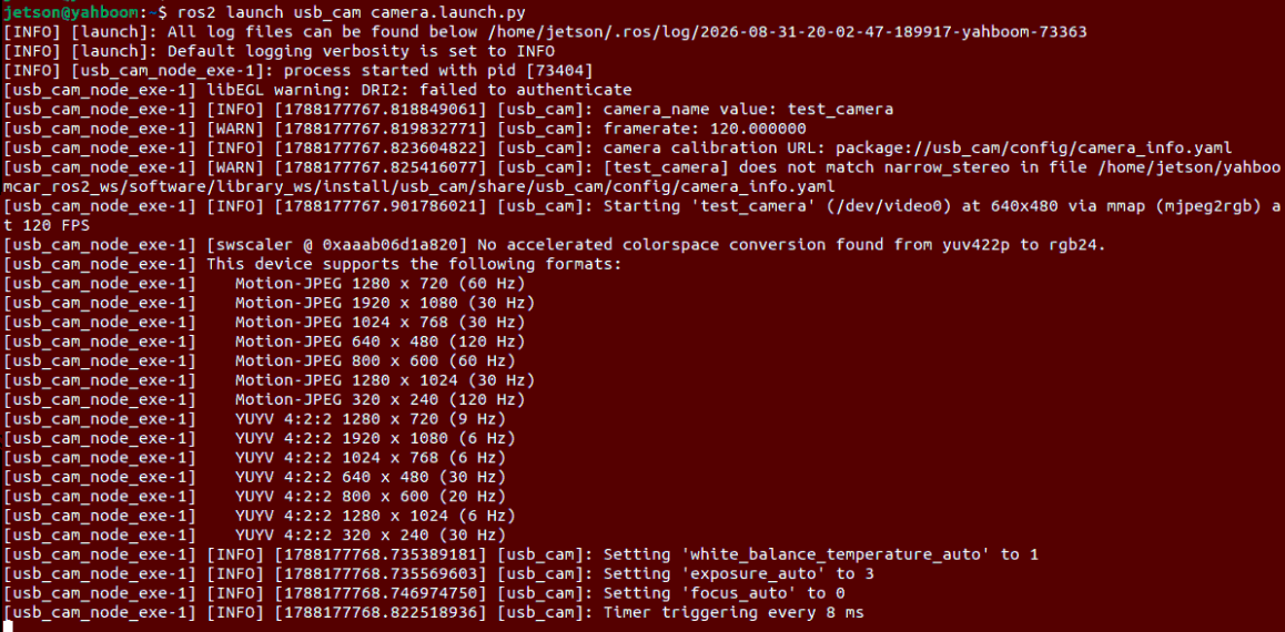
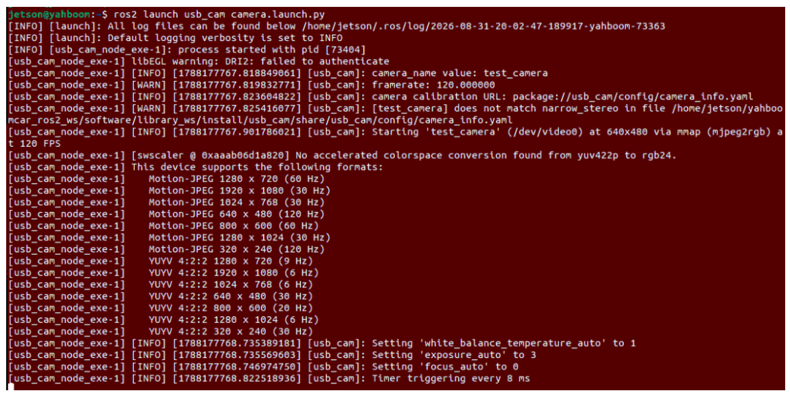
ros2 launch usb_cam camera.launch.py

image-20260831200258764

3.2 Start APP Mapping Service (Choose One)

Run in Terminal 2 the APP mapping bridge node (this Launch automatically pulls up chassis driver, lidar, SLAM mapping node, Rosbridge WebSocket bridge, and APP map save service):

xxxxxxxxxx
# Method A: Gmapping algorithm mapping (recommended)
ros2 launch yahboomcar_nav map_gmapping_app_launch.xml

# Method B: Cartographer algorithm mapping
ros2 launch yahboomcar_nav map_cartographer_app_launch.xml
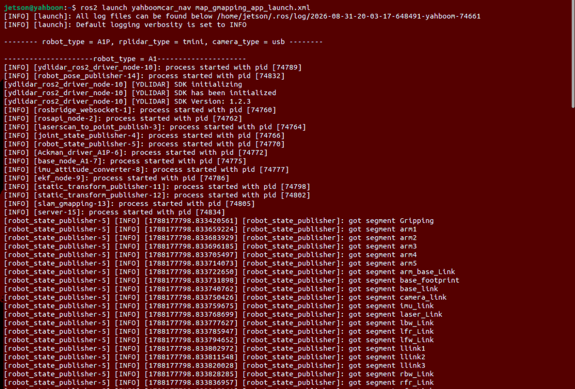
image-20260831200337366

3.3 APP Connection and Mapping Operation

  1. Connect to Robot: Open the ROSRobot APP on the phone, select mapping mode. Enter the robot's LAN IP address, keep the port as default 9090, VideoTopic select /usb_cam/image_raw/compressed (if using Nuwa camera, select the corresponding compressed topic), and click 【Connect】.
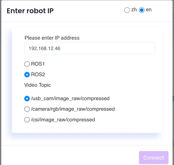
    image-20260831203121578

  2. Remote Control Mapping: After successful connection, the APP interface will display the real-time camera video feed and the raster map generated by the lidar. Use the virtual joystick in the lower-left corner to remote control the robot to move slowly and smoothly, gradually scanning and exploring the entire indoor environment.
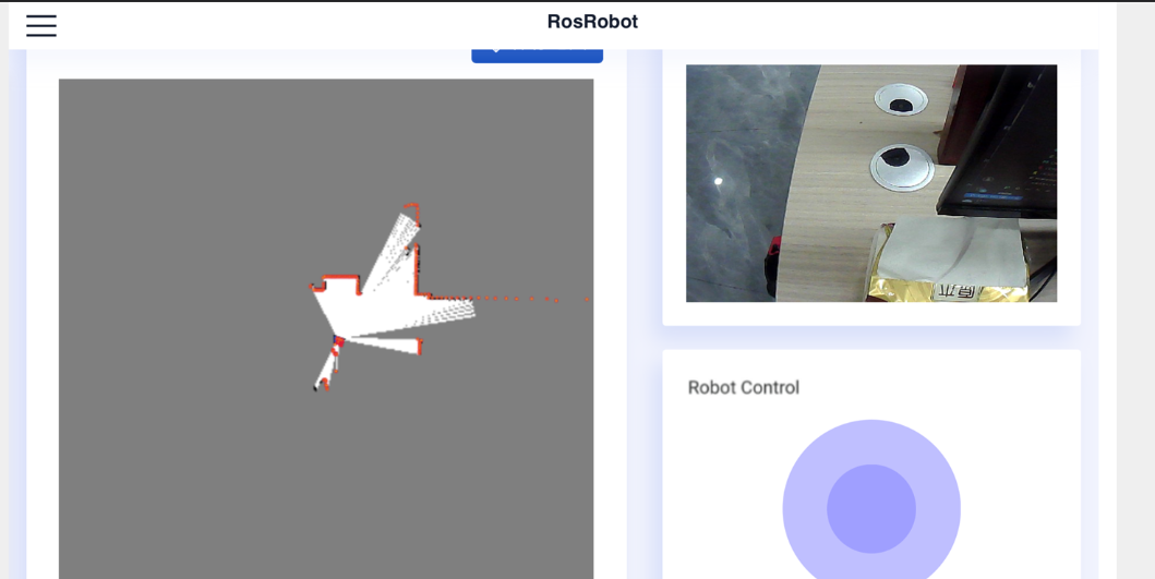
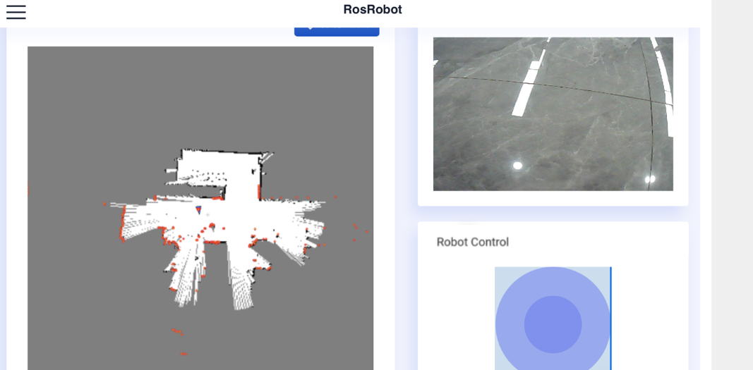
    image-20260831203134487

    image-20260831203159960

  3. Save Map: When the environment outline is completely closed, click the 【Save Map】 button in the upper-right corner of the APP interface, enter the map name (for example test) in the popup, and click confirm.
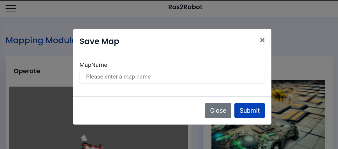
    image-20260831203226175

  4. View Saved Maps: The APP map save service will automatically call map_saver_cli in the background to save the map file to the robot system path:

    xxxxxxxxxx
    ls ~/yahboomcar_ros2_ws/yahboomcar_ws/src/yahboomcar_nav/maps/
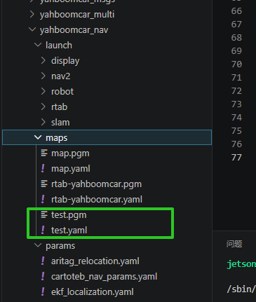
    image-20260831203956634


4. Mobile APP Autonomous Navigation Operation

4.1 Start Chassis and Lidar

Run in Terminal 1 (start A1 Pro chassis driver and lidar):

xxxxxxxxxx
ros2 launch yahboomcar_nav laser_bringup_launch.py
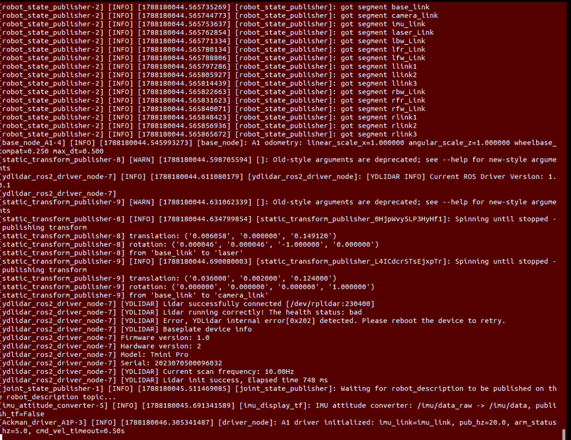
image-20260831204051769

4.2 Start Camera Video Streaming Node

Run in Terminal 2 the camera node:

xxxxxxxxxx
# Nuwa camera:
ros2 launch yahboomcar_depth camera_app.launch.py

# USB camera:
ros2 launch usb_cam camera.launch.py 

image-20260831204146829

4.3 Start APP Navigation Service

Run in Terminal 3 the navigation node:

xxxxxxxxxx
#map:=The path needs to be modified according to the actual mainboard
ros2 launch yahboomcar_nav navigation_teb_app_launch.xml map:=/home/jetson/yahboomcar_ros2_ws/yahboomcar_ws/src/yahboomcar_nav/maps/test.yaml
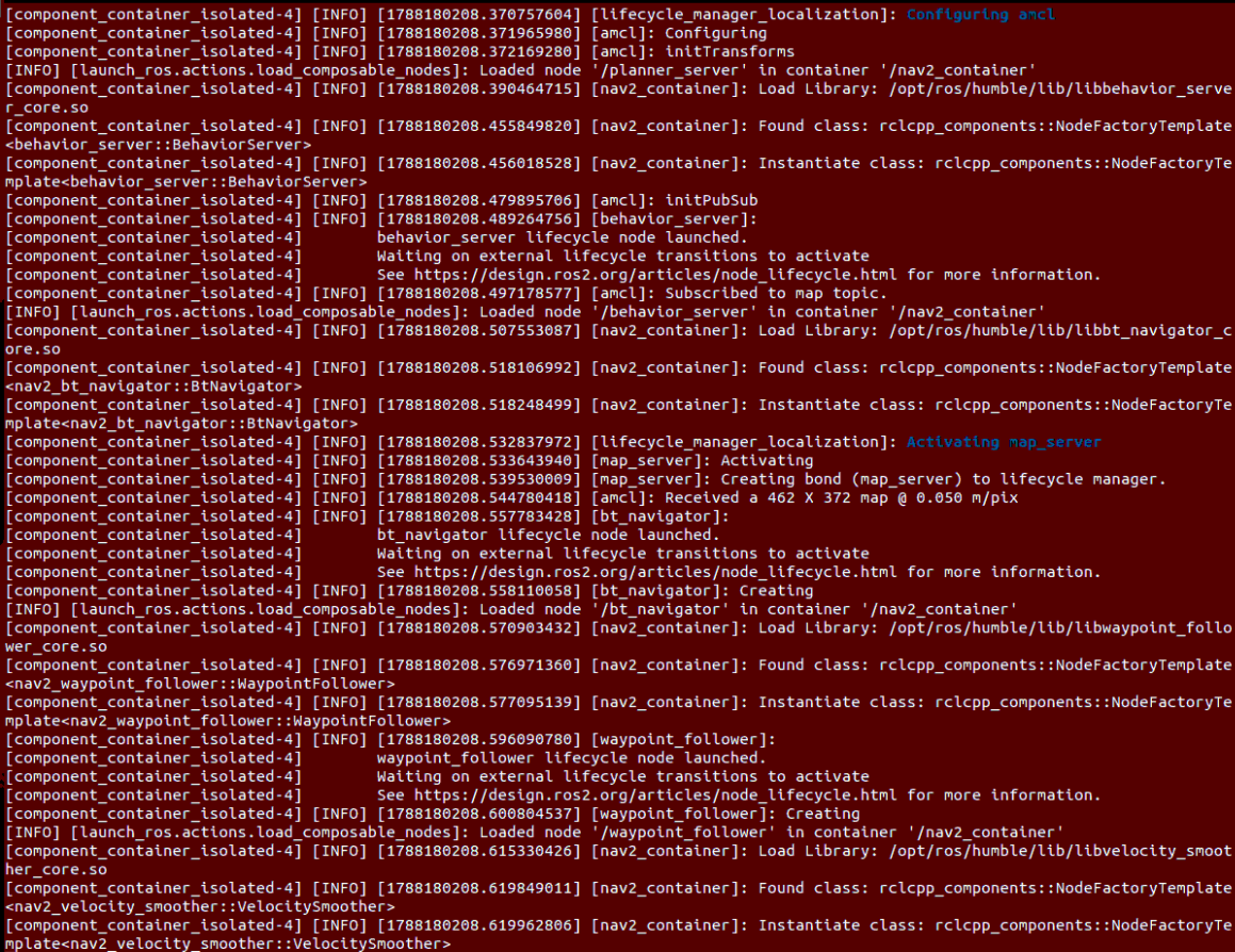
image-20260831204335223

4.4 APP Navigation Operation

  1. Connect to Robot: Open ROSRobot APP, select navigation mode, enter robot IP address and port 9090, VideoTopic select /usb_cam/image_raw/compressed, and click 【Connect】.

    6f27127f4dc6700096fa0e6646a35c16

  2. Enter Navigation Main Interface: After successful connection, the APP automatically loads the map and robot pose:
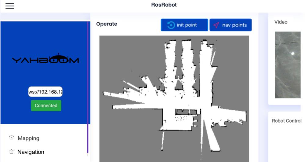
    image-20260831204749323

  3. Set Initial Point (2D Pose Estimate): Click 【Set Initial Point】, click at the actual physical position of the robot on the phone's map screen and pull out the chassis heading arrow. Observe that the red/green scanning point cloud on the map coincides with the black obstacle contours, representing successful initial pose alignment.
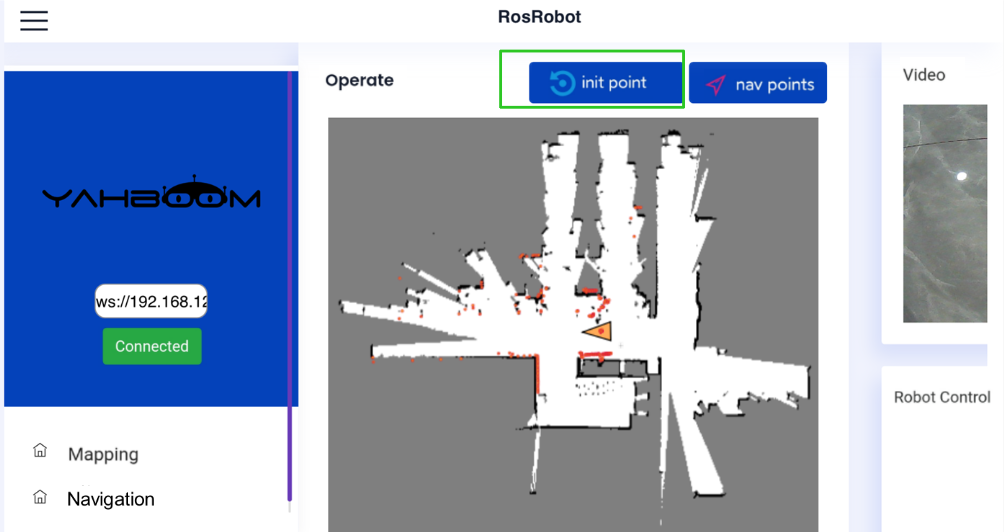
    image-20260831204838741

  4. Set Navigation Goal Point (2D Goal Pose): Click 【Set Navigation Point】, click in the traversable free area on the map and set the goal heading. The robot immediately plans an optimal global path, autonomously controls steering and forward movement, smoothly avoids obstacles, and arrives at the destination.
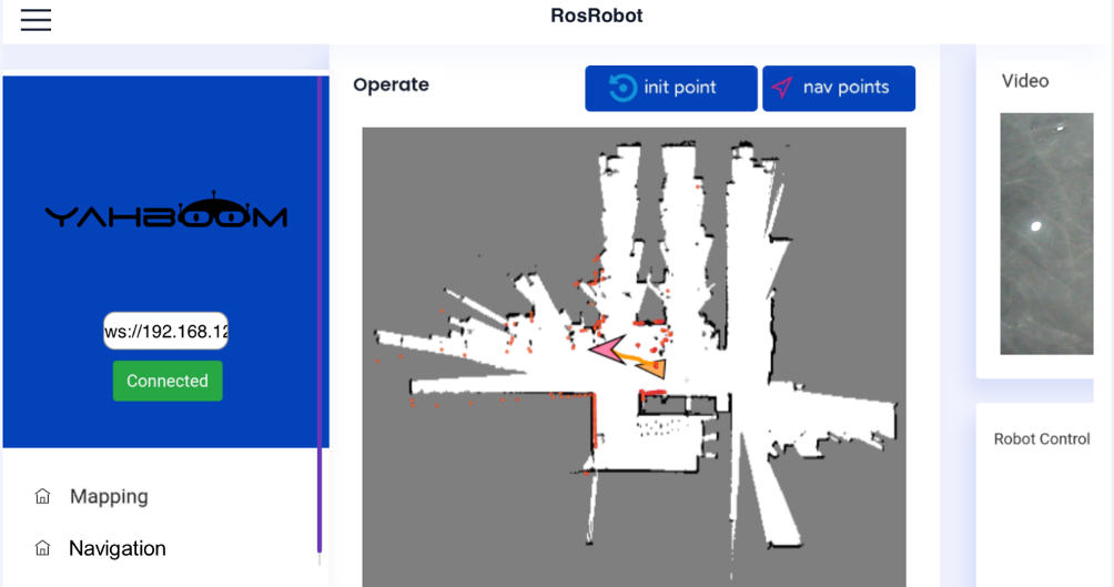
    image-20260831204905187

Note

When you need to end the program, press Ctrl+C in each terminal window to stop the program.


5. Core Source Code and Communication Configuration Analysis

5.1 APP Communication Bridge Architecture Analysis

The mobile APP achieves full-duplex communication with the ROS 2 system through standard WebSocket protocol:

  1. rosbridge_websocket:

    • Listens on port 9090, responsible for transparently forwarding ROS 2 topics, services, and mobile APP JSON messages in both directions.

    • APP-published control commands are transformed into /cmd_vel to drive the chassis; APP-set pose points are transformed into /initialpose and /goal_pose and passed to Nav2.

  2. robot_pose_publisher:

    • Real-time listens to the map -> base_footprint in the TF transformation tree, calculates the robot's absolute coordinates and heading in the global map, and high-frequency sends to the APP interface via /robot_pose topic to draw the robot icon.

  3. laserscan_to_point_publisher:

    • Converts lidar scan data into a compact point cloud format, providing real-time obstacle point cloud outline for APP rendering.

APP Navigation Launch Architecture Configuration (navigation_teb_app_launch.xml):

xxxxxxxxxx
<launch>
    <!-- Start rosbridge websocket bridge service -->
    <include file="$(find-pkg-share rosbridge_server)/launch/rosbridge_websocket_launch.xml"/>
    
    <!-- Start lidar point cloud publishing node -->
    <node name="laserscan_to_point_publisher" pkg="laserscan_to_point_publisher" exec="laserscan_to_point_publish"/>
    
    <!-- Start TEB navigation core -->
    <include file="$(find-pkg-share yahboomcar_nav)/launch/nav2/navigation_teb_launch.py"/>
    
    <!-- Start robot map pose publishing node -->
    <include file="$(find-pkg-share robot_pose_publisher_ros2)/launch/robot_pose_publisher_launch.py"/>
</launch>

5.2 APP Map Save Service Source Analysis

Source Code Path:

xxxxxxxxxx
$HOME/yahboomcar_ros2_ws/yahboomcar_ws/src/yahboomcar_app_save_map/yahboomcar_app_save_map/yahboom_app_save_map.py
xxxxxxxxxx
class MinimalService(Node):

    def __init__(self):
        super().__init__('minimal_service')
        # Create ROS 2 service to receive APP map save requests
        self.srv = self.create_service(WebSaveMap, 'yahboomAppSaveMap', self.add_three_ints_callback)
        
    def run_shellcommand(self, *args):
        '''Execute shell command and run map_saver_cli in background'''
        args = sum([(arg if type(arg) == list else [arg]) for arg in args], [])
        possess = subprocess.Popen(args, stdout=subprocess.PIPE)
        return possess

    def add_three_ints_callback(self, request, response):
        map_name = request.mapname
        workspace_src = Path.home() / 'yahboomcar_ros2_ws' / 'yahboomcar_ws' / 'src'
        map_path = str(workspace_src / 'yahboomcar_nav' / 'maps' / map_name)
        database_path = workspace_src / 'yahboomcar_app_save_map' / 'yahboomcar_app_save_map' / 'xgo.db'
        
        # Record map name and timestamp information into local SQLite database
        now = datetime.datetime.now()
        str_time = now.strftime("%Y-%m-%d %H:%M:%S.%f")
        map_id = hashlib.md5((str_time + map_name).encode()).hexdigest()
        response.response = request.mapname
        
        try:
            conn = sqlite3.connect(str(database_path))
            c = conn.cursor()
            c.execute("INSERT INTO xgo_map (map_name, map_id, map_path) VALUES (?, ?, ?)", (map_name, map_id, map_path))
            
            # Call Nav2 official map_saver_cli node to save .yaml and .pgm raster map
            self.run_shellcommand(
                'ros2', 'run', 'nav2_map_server', 'map_saver_cli',
                '-f', map_path,
                '--ros-args',
                '-p', 'save_map_timeout:=10.0',
                '-p', 'map_subscribe_transient_local:=false',
            )
        except sqlite3.IntegrityError as e:
            response.response = {"msg": str(e)}
            return response     

        self.get_logger().info('Map saved successfully: %s -> %s' % (map_name, map_path))
        return response
  • This node creates the yahboomAppSaveMap service (type is WebSaveMap). When the APP clicks Save Map, it sends a request with the map name; while writing map metadata to SQLite database, the node asynchronously calls nav2_map_server's map_saver_cli command-line tool to persistently save the current global occupancy raster map as maps/<map_name>.yaml and maps/<map_name>.pgm.


5.3 Core Communication Parameters and Port Description

Communication ModuleService/Topic/PortDefault Config ValueCore Function Description
WebSocketListening port9090ROSBridge service port, handles APP JSON control commands and topic broadcast
Video StreamingCompressed image topic/usb_cam/image_raw/compressedLow-latency compressed video stream provided to APP for rendering
Pose PublishingTopic name/robot_posePublishes robot's real-time position and attitude in global map coordinate frame
Point Cloud PublishingTopic name/scan_pointLidar point cloud coordinate transformation publishing, used by APP to draw obstacle point cloud
Map SaveService nameyahboomAppSaveMapReceives map name sent by APP and calls map_saver_cli in background to save
Aruco Visual Relocalization Navigation
AprilTag Transport

COMPANY

  • About us
  • Team Style
  • Blog

LEARNING & EXPLORATION

  • Tutorials
  • Edge AI hardware
  • Educational robots
  • Embedded intelligent hardware

WHERE TO BUY

  • Yahboom Online Store
  • Amazon
  • Alibaba
  • AliExpress
  • Mercado

TECHNOLOGY SUPPORT

  • Email: support@yahboom.com

BE A DISTRIBUTOR

  • Email: sales@yahboom.com
QR Code

Copyright © 2017-2026 Yahboom. All Rights Reserved.

EN/中文